INDEX - DEVELOPMENT
www.islandbreath.org ID# 0402-08

SUBJECT: KAUAI PARKS: PUOLO POINT

SOURCE: JUAN WILSON juanwilson@mac.com

POSTED: 10 NOVEMBER 2004 - 10:00am HST

Kauai Parks & Recreation Master Plan


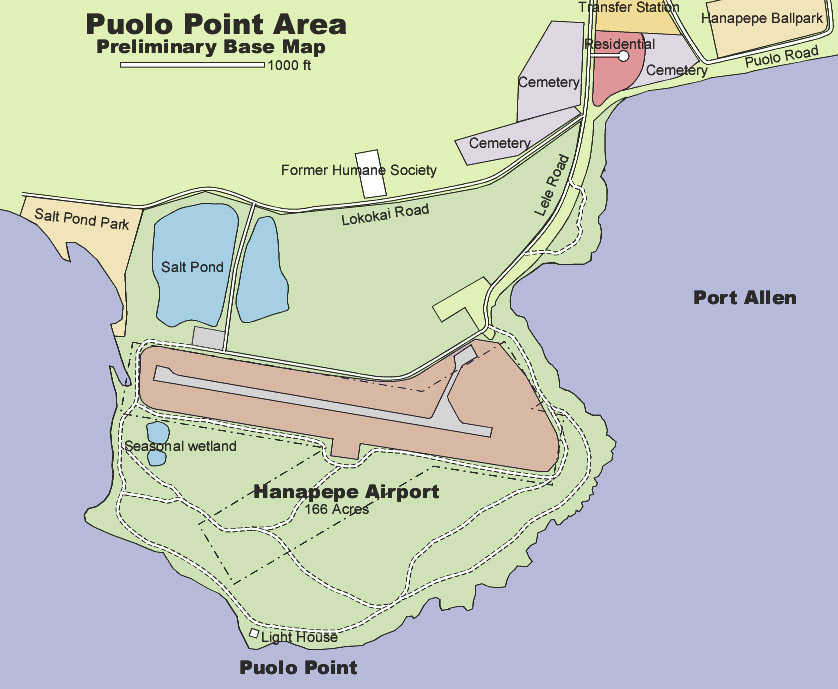
This is a detail of the Puolo Point Base Map showing some of the existing conditions around the site dated 9 November 2004

by Juan Wilson: Architect - 10 November 2004

The map above is an update of the previously published base map. The major changes to the map are:

• added location of certified archeological/heiau site east of light house
•added location of suspected heiau site east of former Humane Society
• adjustments to the location of dirt roads south of the airport

• inclusion of tree stands and forested areas
• identifications of seasonal wet spots in grasslands
• identification of sand beaches and some points of shhoreline interest
• addition of heliport and Salt Pond Beach facilities

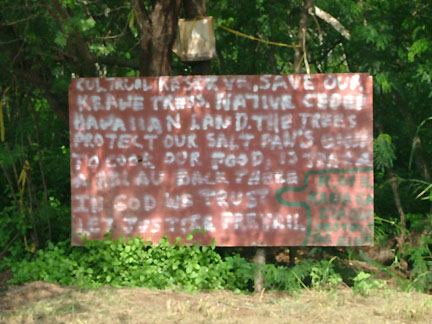
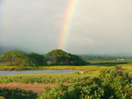
With recent rains the grasslands covering much of the Puolo Point area are thriving. There are many wet spots and seasonal wetlands that can be identified at this time.

The possible site of a heiau east of the former Humane society was described by Ben Kali, a native Hawaiian (kanaka maoli) who maintains a sign that requests preservation of the Keawe forest and identifying the location of the possible heiau. This sign can be seen from Lokokai Road.

The sign reads:


CULTURAL RESERVE. SAVE OUR
KEAWE TREES. NATIVE CEDED
HAWAIIAN LAND. THE TREES
PROTECT OUR SALT PANS. WOOD
TO COOK OUR FOOD. IS THAT A
A HEIAU BACK THERE
IN GOD WE TRUST
LET JUSTICE PREVAIL


K OF K
KANAKA
MAOLI
PROTECT
THE AINA

"K OF K" refers to Ben Kali of Hanapepe, Kauai. When asked about the meaning of the sign he said that he put up the sign when the Kauai County tried to clear the area around the Humane Society site several years ago. Ben said that the county intended to clear the trees and brought in a bulldozer that pushed rocks around at an area he suspects is a heiau site. Ben added that he does not believe the area is actually "ceded lands" anymore. It is his opinion that the land was never part of the Hawaiian Kingdom but part of the Kingdom of Hawaii and thus part of Hawaiian ancestral lands that are to this day in the control of Kauai kanaka maoli.

We encourage readers to submit information, history or observations that will enrish the building of the Puolo Existing Conditions Base Map. Of particular interest would be information useful to identify fishing and other recreatinal uses of the area.

To download a PDF file (379k) of the current Base Map click here.


SUBJECT: KAUAI PARKS MASTER PLAN

Puolo Point Existing Condition Base Plan

SOURCE: JUAN WILSON

juanwilson@mac.com 4 October 2004 - 8:30am


This detail of the Hanapepe Airport Planning Base Map shows the area mauka of Puolo Point as far north as the Hanapepe Ball Park

by Juan Wilson: Architect - 4 October 2004

Above is detail of a preliminary base map that can be used by interested parties to help plan the future for the Hanapepe Airport area, focusing on the grasslands, seasonal wetlands and rocky coastline around Puolo Point. South of the existing airport this area contains almost 100 acres. This area is now used informally by the public for recreational use that includes fishing, camping, hiking, sunset watching, off-road vehicular play.

The area is unique environmentally in that it is land that is large, open, level, on the shoreline and unused by private agriculture. It provides seasonal wetland areas for birds and other wildlife and includes a number of native owls at the top of the foodchain. Parts of the Puolo Point area should be designates as wilderness refuge to ensure the continuation of this environment.

Back in October of 1977 the county of Kauai had Aotani & Hartwell Associates prepare a final draft of a Kauai Parks & Recreation Master Plan. To my knowledge there is no later study by the county of its comprehensive recreational needs. The study breaks the island into a half a dozen districts and identifies the current and future needs as well as prioritize them.

The district including Hanapepe also included Eleele and Kaumakani. The Master Plan includes a profile of this district. Under Physical Characteristics the document states:

"Hanapepe-Eleele is the dominant community within the planning area"

"Natural resources for recreation within the planning area include hanapepe Valley, Hanapepe Bay, Wahiawa Bay, and the historic Salt Pond site."

"A county beach park has been established just west of the (Salt Pond) site."

Although Hanapepe Valley is not being used for recreation, its recreational value has been recognized by the Hanapepe-Eleele Development Plan."

"The planning area has few coastal areas which can be developed for beach recreation. Only Salt Pond beach has been developed for recreation. Wahiawa Bay has beach recreational opportunities but is located on private land... "

The master plan goes on to detail existing and anticipated needs and the resources to meet those needs. In the Summary of Needs the master plan states:


"In most cases, the needs for active recreation and neighborhood facilities can be satisfied at existing parks. At Hanapepe, implementation of the County master plan for Hanapepe Ball Park will meet existing community and district-level needs for playing fields and courts. Hanapepe Town Park and Hanapepe Pavilion Park can meet the needs for passive recreation."

"Recreation based on natural resources are in short supply. If more shoreline recreation cannot be provided with the planning area, shoreline opportunities should be provided in other planning areas."


This last paragraph goes to the heart of the issue concerning the future plans for Hanapepe Airport. If it was true in 19977, the need for "recreation based on natural resources" is true today. To meet The Puolo Point area should be identified as a much needed and well used natural shoreline recreational area. Future planning should expand, enhance and strengthen what might become the Puolo Point Shoreline Recreational Area.


SUBJECT: KAUAI PARKS

Baptiste's terrible plan for Salt Pond!

SOURCE: JUAN WILSON

juanwilson@mac.com 20 August - 10:30pm


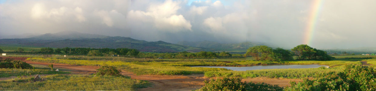
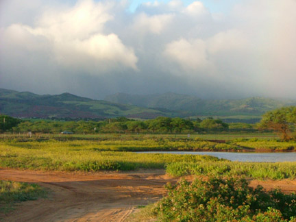
Panorama looking inland to the north and the east from near Salt Pond Beach Park south of the airport

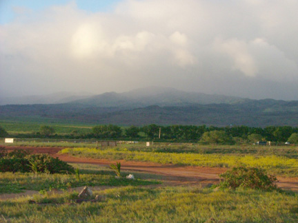
by Juan Wilson: Architect - 20 August 2004

The idea of developing a regional sports center in the "badlands" south of Burns Field (Port Allen Airport) is one of the worst ideas to come from Mayor Baptiste since he suggested closing the public parks after dark. The area in question for his Salt Pond Park Plan runs the full length of the airport's south border and reaches to the ocean at Puolo Point. For the sake of this article let's call the area the Puolo Plain. As the panorama above illustrates the Puolo Plain is one of the few large publicly accessed areas untouched and undeveloped along the shores of Kauai.


Now it is true that there is some trash left in the area by visitors. It is also true that occasionally people camp along the shore for extended periods without permits. It is an area that is not heavily trafficked and is left pretty much to nature. My thought is why spend a lot of money to wreck a place that is just doing fine by itself.

Sure, there would be oodles of money involved in spreading a lot of blacktop and building a bunch of bleachers and surrounding it all with a wire fence. There would be lots of maintenance, electricity and water required to keep it all going. But what is the point.

I live in Hanapepe and use this area frequently. I pass the town's sports facilities quite often. We have many acres of football fields, tennis courts and baseball fields. Most of the time they sit empty. When they are used, it is often in the evening, and the fields are lit up like day with tall night-lighting towers. The last thing needed in this wilderness area is a large crowd of people screaming in unison under night-lights.

I have seen owls and other rare birds hunting on the Puolo Plain. There are seasonal wetlands in the area as well. There is a grassland ecosystem operating here that you don't find in other places on Kauai.

Without any cost to the public, the Puolo Plain is on of the joys of living in Hanapepe. It is one of the best places to whale watch, wave watch, star watch or just watch the sun go down. There are no 50' high lighting standards or utility poles to spoil the view. There is hardly any ambient light from sodium arc lamps to spoil the night sky.

If the mayor is really hell-bent on spending some money, why doesn't he have the county clean up the litter and put out a few trash cans for visitors.


Mayor wants to expand Salt Pond Beach Park
by Lester Chang, staff writer, The Garden Island News:
20 August 2004

For years, West Kaua‘i families have enjoyed snorkeling, fishing and picnicking at Salt Pond Beach Park in Hanapepe.

If Mayor Bryan J. Baptiste has his way, recreational activities will be expanded significantly in areas around the park in the future. But Baptiste says the biggest challenge is finding funding.

On Tuesday, Baptiste announced plans to develop the Hanapepe/Salt Pond Regional Park within 150-plus acres on the Hanapepe peninsula.

If and when established, the enlarged park would operate in unison with the existing Salt Pond Beach Park, consisting of about six acres, and the nearby Hanapepe Stadium complex, consisting of about 15 acres.

The creation of the regional park would greatly enhance recreational opportunities for West Kaua‘i residents, and would provide more park space for sporting events and practice sessions for competing sporting organizations, Baptiste said during a meeting in his office at the Lihu‘e Civic Center.
New sporting facilities could be built as well to address recreational needs in West Kaua‘i, the mayor said.

Baptiste said he and his staff have worked with officials with the state Department of Transportation Airports Division to lease 133 acres of land in the Salt Pond peninsula area in Hanapepe for the proposed regional park.

A draft lease for the 133 acres is pending, Baptiste said. After review by count officials, including the Kaua‘i Office of the County Attorney, the draft lease will be sent to the Kaua‘i County Council for input and action.

County leaders have applied for an executive order to use the 133 acres, Baptiste added. Because the land would be used for public recreation, Baptiste said he doesn't believe a time restriction would be inserted in any lease that is consummated.

At the same time, Baptiste is requesting a 17 1/2-acre triangular parcel from the state Department of Land and Natural Resources near the 133 acres, to complete the boundaries of the proposed park.
The smaller parcel was used at one time for a bus operation, and in proposed uses could be the site for maintenance facilities and equipment for maintenance of the new park, Baptiste said.

"I believe the regional park should be the source through which we can develop the recreational resource," Baptiste said in assessing the future recreational benefits of the project.

One of the benefits of developing the park is "logistics," meaning compared with neighborhood parks, regional parks would "have a better economy of scale relating to maintenance, manpower and equipment," Baptiste said.

Because of better maintenance, regional parks "typically have higher-quality fields and facilities," Baptiste said.

The regional park would allow sports clubs more fields and space for games and practice sessions, Baptiste said.

"It will take the stress off neighborhood parks for practice and games," he said. "We are a growing a community.
"

Developing the regional park will create challenges, he said. County officials are very likely to face restrictions for projects proposed near Burns Field (Port Allen Airport), which is located on a peninsula in Hanapepe and is managed by the DOT Airports Division.

"Eventually, we would like to turn the whole peninsula into a park area," Baptiste said. "But at this point, we respect and support the Department of Transportation's decision to maintain an airport there."
But even with the restrictions, the community can still work with him and other community leaders in developing a suitable plan that would stay "within the state's restrictions and guidelines," Baptiste said.
Baptiste said he would welcome community input, and indicated that community meetings are planned for that purpose "We want to start the process of talking with the community to see what they would like to see," Baptiste said. "There are no pre-conceived plans here."

Access rights of fishermen are likely to be a high priority, Baptiste indicated.

"There are great fishing opportunities, and we want to make sure nothing we do violates that," he said. "We want to make sure fishermen are included in the process, so that the development of the park doesn't interfere with their sport," Baptiste said.

He said the proposed regional park is just an idea at this point, but it can become a reality if government and residents are committed to seeing the park developed.

"What we need to do is develop the dream together," Baptiste said.


Funding for the proposed regional park has not been identified, and more than likely, once the plans are developed and construction is imminent, a bond will be floated to build numerous projects including the park, Baptiste said.

Baptiste also said he wants to see other regional parks developed in Lihu‘e and in the North Shore one day. Related to a regional park envisioned for Lihu‘e, Maxine Correa, a former chairwoman of the council, had proposed something similar to it years ago for the benefit of residents. She had proposed a sports complex that would have incorporated the Vidinha Stadium.


www.islandbreath.org

Pau