INDEX - MILITARY
www.islandbreath.org

SUBJECT: PMRF LAND REQUEST - PART TWO

SOURCE: JUAN WILSON juanwilson@mac.com

POSTED: 15 March 2004 - 9:30am HST

Nohili Park Initiative (NPI) Presented on Hoike


Still from Hoike Public Service Address on PMR

by Juan Wilson on 15 March 2004

HOIKE PUBLIC SERVICE ANNOUNCEMENT
A seven minute video presentation of an alternative to the current PMRF expansion plan is scheduled for airing this week, ending March 19th and running the week after next beginning March 29th, Monday thru Friday. The Nohili Park Initiative spot will run at the end of the Open Mic segment on Oceanic channel 52. This should be about 12:35pm and 6:35 pm. For more info about Hoike Kauai Community Telivision look at Hoike.org

Below is the original script of the presentation. Due to editing, some items were trimmed to meet time constraints in the broadcast version.

THE NOHILI PARK INITIATIVE
Aloha. My name is Juan Wilson. I’m presenting an alternative to the Navy’s request to expand
the Pacific Missile Range Facility.

MY BACKGROUND
I’m an Architect & Planner
With 30 years exerience working in New York & Connecticut and now in Hawaii.
I have some experience with community supported shoreline planning.
I was an

• Architect for the Fairfield Connecticut Barrier Dune Restoration Project in 1985
• C-Chair of Pine Creek Connecticut Wetland Restoration Master Plan in 1989 and
• Co-Chair of the Jamestown New York Chadakoin River Planning Committee in 1992.

I’ll explain my plan in a moment, but first some background about the PMRF site.

PMRF BACKGROUND
In the past the beaches from Kekaha to Polihale were used mostly for fishing, camping and watching sunsets. Inland was wetland and farming.

The use of the area by the military began by an executive order in 1940. A site of about 550 acres was put aside to be used for bombing practice. Since then the site’s mission has changed as it has expanded north and south. Over 1500 acres have been added to it. In 1966 the base was named the Pacific Missile Range Facility.

PMRF MISSION
The primary mission of the PMRF is facilitating the testing of high-tech military systems.
Unfortunately, since 9-11 the Navy has used terrorism as an excuse to close miles of beaches from public access on the longest beach in the state of Hawaii.

SUGARCANE FAILURE THREAT
Now, besides terrorism, the Navy sees a new threat to the PMRF. Changes in agriculture. Due to a failure of sugarcane as a profitable crop in Hawaii, the Navy’s been worried about future development of the Mana Plain. Will agriculture be replaced with suburbia?

Well, now the Navy has a plan.

The Navy originally called its plan the “Passive Encroachment Buffer”. This plan received such negative response from the public it was withdrawn and renamed the "Agricultural Preservation Initiative", or API.

WHAT IS THE API?
The Navy has put two land requests together when presenting the API.
It is asking the State for a long term lease on over 400 acres of land in order to expand the base.
This acquisition will include taking over the water pumping operations that drain the Mana Plain and keep it from returning to a rustic wetland.

The Navy is also requesting special power restrict and detrermine land use on the 5000 acres of agricultural land north of the County Landfill.

WHY THE API?
The reason the Navy says it is advocating its API is to protect the base with a new “buffer” of land and to keep things from changing in the surrounding area. However, lack of change is the least likely scenario for the future.

The API will essentially give the Navy (and its sub-conctractors) more land and more control over the westside of Kauai. Expanding the PMRF lease and having the military as an authority over civil affairs is an unwholesome idea, and unnecessary. There is a better plan.

That alternative is the Nohili Park Initiative, and covers the same area as the Navy API Plan.

WHAT IS THE NPI?
Rather than expand the existing PMRF Base, the NPI advocates that the Navy should make a phased relocation inland, away from the shoreline. In its place would be an expansion of the state park and DLNR wetlands.

The new NPI plan adds new details the Mana Land Use Plan, such as the recreation of Nohili and Kawaiele Ponds, and showing possible replacement runway locations and alignments.

WHY RELOCATE THE PMRF?
From the navy point of view... security. A compelling consideration comes from a recent Pentagon report on climate change. It was authored by Peter Schwartz, CIA consultant and former head of planning at Royal Dutch-Shell. The experts privy to the report say it shows the threat to global stability from climate change vastly eclipsing that of terrorism.

The report indicates, “An imminent scenario of catastrophic climate change is plausible and would challenge US national security in ways that should be considered immediately...
If this Pentagon report is right, Hawaii is threatened in two ways by global warming. Rising seas and chaotic ocean storms. This will be more of a threat to the PMRF than terrorism has been, and action should be taken now. To reduce that threat the PMRF should begin planning a move away from the shoreline where it will otherwise be at the mercy of future catastrophic climate change.

WHAT ARE THE PROS & CONS?
Well the PROS:
With the NPI plan the Navy will have a more secure and consolidated site. It would be trading two existing 6000 foot runways for two new 10,000 foot runways.
The proposed increase of State Park from approximately 300 acres to over 1300 acres will greatly increase the public access to beaches and create new recreational areas. The area will be large enough to establish a program of dune wilderness restoration and preservation.
The wetland environment, as well, will be greatly expanded; enhancing the natural beauty of the area. For the first time in generations, wetlands will be connected behind the barrier dunes from the mountains to the ocean, helping many species to escape extinction. These wetlands will again absorb storm surge and flooding, and will help protect surrounding agriculture, and park land, as well as the PMRF itself.
The NPI plan will also offer opportunities at the south end of the site for private development in agricultural processing and suitable high tech enterprises.
What are the CONS?:
Although the NPI will be good for the military, the environment and public access, it comes with a reduction of current farming practice. The NPI plan anticipates almost 50% less agriculture landuse over the next twenty years.

IN CONCLUSION
. Like the API, the NPI forsees difficulties for Mana Plain farmers in the future. But, unlike the Navy’s API, the NPI faces the issue of landuse change and global warming head-on. It considers the needs of current interested parties and makes the case for a bold solution. We should not invest more in a badly located military base that is threatened by the future.

WHAT YOU CAN DO?
Get involved. Review the current proposals. Attend public meetings and express your opinion. It matters.


SUBJECT: PMRF LAND REQUEST: PART TWO

SOURCE: JUAN WILSON juanwilson@mac.com

POSTED: 23 FEBRUARY 2004 - 5:30pm HST

A brief review of the Navy's presentation


Surf break near Barking Sands

It is encouraging to see so many Kauai residents, interested and speaking out about the significant changes being proposed by the Navy over the management and expansion of the PMRF. I agree with those who say complaining is not what is called for. Good planning is.

At the 19 February meeting of the County Council Finance & Intergovernmental Relations Committee, Navy Captain Connelly presented his case for the PMRF land requests of the State concerning over 5000 acres of agricultural land on the Mana Plain.
There are two components to the Navy request.

Item One: The "Agricultural Preservation Initiative" (formerly the “Passive-Encroachment Buffer” ). This “API” would affect the bulk of agricultural land north and west of the County Landfill. The "API" would allow the Navy veto power over agricultural uses that would "interfere" with PMRF operations. namely radio signals and lights. This “API” will essentially give the US military a seat on the Kauai County Planning Commission and other civilian review processes. This is a bad idea. We should let civilian State and County representatives continue to to do their jobs.

Item Two: The 25 year lease (the maximum allowed by State law) on 415 acres of land adjacent to the base. Connelly stated that the the new leased land is meant to serve as a buffer to the base needed because of regulations as a result of 9’-11. He said without the buffer the Navy could not develop up to its fences. Using the Navy's tortured logic the 425 acres is really not an expansion but merely an adjustment that will allow the PMRF to fully use the land it has already. What kind of nonsense is this? The reality is 415 acres is still 415 acres.

Under questioning from JoAnn Yukimura, Connelly said the buffer required was 150 feet wide. At a 150' wide the 415 acres would provide 22 miles of buffer. The base needs less than 6 miles stretching from the shrimp farm near the landfill to Queen's Pond for such a buffer. That means that the acreage needed for the base "to build to its fences" is actually only 100 acres. In fact, like every other lessee, the PMRF needs no additional land if it does not build to its “fences”.

At one point Connelly showed two identical images of the base that were labeled "Before" and "After". The punchline being “No Change”. Connelly stated the PMRF would have no impact on the island if its requests were met. This is flimflam. It was pointed out that the "After" shot should at least show the items already proposed by the PMRF for the expansion area; the new base entrance, the visitor's center, a parking lot, the perimeter fence and the perimeter road.

As part of the expansion, the PMRF has also "volunteered" to take control of pumps that are owned by the State to lower the water table on the Mana Plain. These pumps drain the agland that would be wetland otherwise. The Navy would "save" the State having to charge farmers $600,000 a year to do this maintenance. Councilman "Joe" Munechika, with Mana farming interests, seemed interested in the lower lease fees if the Navy covered this cost of pumping.

But at what cost to the public will the cost savings amount to? This is a concern because the Navy could easily "hide" the toxicity and content of Mana Plain effluent under the guise of "National Security". With GMO crops a growing business on the Mana Plain, runoff to the offshore coral reefs needs monitoring. It would be better if the State and agricultural lease holders maintained control of the agland pumps and were kept responsible for what they pumped into the sea.

We think it would be better for the County and State if the PMRF simply paid their fair share of property taxes for the property they occupy. Under the present agreement the Navy only pays the State a few hundred dollars a year for 2000 acres of land.

In the Public Testimony segment of the meeting this plan was presented as an alternative Mana Plain Land Use Plan. You can evaluate that plan for yourself on the web, here.

This is a color jpg file about 425kb. It is 96 dpi at 11"x17". Print at 65% of its original size to ft on 8.5"x11" paper. A more detailed PDF file is available on request from Juan Wilson


That alternative Mana Plain Land Use Plan does not eliminate the PMRF or move it in its entirety. The plan proposes that the Navy begin trading state land against the Mana hillside (near the end of Kao Road) for land at its PMRF base.

As pleasant as it may be, such things as baseball fields and golf driving ranges for PMRF staff don’t have to be on the base or near the beach. Do we really need PMRF surfside nightclub or VIP rental cottages on the beach to defend our country against terrorism? If the military and private industry need more space at the PMRF let them move or eliminate acre gobbling recreation facilities. In fact if they have new operations in the planning stage let them be located away from the beach so that in time our shorefront can be returned to us.

In the end a significant portion of PMRF operations could be relocated away from the shoreline. Then we might be able to have a wonderful expansion of State Park between Queen’s Pond around Nohili Point down to Mana Point. That would be worth planning ahead for. What is the “payoff” for the Navy? Acceptance and support by the people of Kauai for being a good neighbor. That should not be underestimated. Just look to the history of the Panama Canal Zone, Vieques Island, Puerto Rico and Kahoolawe, Hawaii if in doubt.

If you are interested in this issue, don't miss the Mayor's Ka Leo O Kauai community meeting in Kekaha Tuesday 24 February 7pm at the Kekaha Neighborhood Center. The Navy will present again.

The bottom line. The County should not support the poorly thought out efforts by the Navy to have more land and influence on Kauai unless the PMRF is willing to plan and contribute to what is best for Kauai and it’s people. It’s all about the aina.


SUBJECT: PMRF LAND REQUEST

SOURCE: JUDY DALTON dalton@aloha.net

POSTED: 13 FEBRUARY 2004 - 11:30pm HST

PMRF Requests to Make a Presentation


Polihale: A place of spiritual departure for Hawaiians increasingly becomes the stoneface of the US military

ALERT!! A Public Meeting you should attend!

This is a headsup on a public meeting at which the PMRF will try to convince the County Council of a plan to take over control of much of the westside of Kauai. Judy writes;

"It looks like the Navy is now trying to woo the County Council on their "revised" plan:"

COMMITTEE MEETING NOTICE AND AGENDA
THURSDAY, FEBRUARY 19, 2004 - 9:00 A.M.
COUNCIL CHAMBERS
HISTORIC COUNTY BUILDING
4396 RICE STREET, ROOM 201
LIHUE, KAUAI, HAWAII
 
 
FINANCE/INTERGOVERNMENTAL RELATIONS COMMITTEE
Minutes of the February 5, 2004 Finance/Intergovernmental Relations Committee Meeting.F/IGR 2004-1 Communication (2/9/2004) from Maurice Munechika, F/IGR Committee Chair, requesting agenda time for Commanding Officer Captain Connelly of the Pacific Missile Range Facility (PMRF) to discuss the proposed Agriculture Preservation Initiative.


SUBJECT: PMRF LAND REQUEST

SOURCE: JUAN WILSON juanwilson@mac.com

POSTED: 6 FEBRUARY 2004 - 8:30am HST

Navy Flacks Rename Bad Program


Aerial view of part of 7.5 miles of beach no longer available to Hawaiian residents

by Juan Wilson on 6 February 2004

Don't miss the Mayor's Ka Leo O Kaua‘i community meeting in Kekaha Tuesday 24 February 7pm at the Kekaha Neighborhood Center. Mayor Bryan J. Baptiste, who attended the January meeting, said there were some people upset that Base Access had been taken off the community priority list. The plan is to go through the prioritization process at February meeting.

The PMRF representatives were nearly driven from the podium at the public hearing on November 13, 2003 when they presented their 6,000 acres "Passive-Encroachment Buffer" request of the DLNR. Since then the Navy has put it's best PR flacks on the case and have renamed their attempt at controlling the westside the "Agriculture Preservation Initiative". Doesn't that sound bucolic? Below is a portion of a Garden Island News article about the Navy land grab in Mana surrounding the site of the PMRF facility.


PMRF's Connelly explains buffer plan in Kekaha
By TOM FINNEGAN - TGI Staff Writer 5 February 2004 - 5:00am


At the first Ka Leo O Kaua‘i Kekaha meeting of the year on Jan. 24, Pacific Missile Range Facility Commanding Officer Capt. Robert J. Connelly surprised some Kekaha residents with his discussion of both beach access and the proposed 5,860-acre easement around the base.

"We're making a renewed effort to get out in the community" to discuss the proposal, said Lt. Cmdr. Jeff Davis, public information officer for the Navy region public affairs on O‘ahu. The proposal even has a new name. It was called a "passive-encroachment buffer" at the Nov. 13 meeting on the subject with the state Department of Land and Natural Resources.
Now, according to a news release on the Navy Region Hawai‘i's Web site (www.hawaii.navy.mil), the proposal is called the "PMRF Agriculture Preservation Initiative."

Its goal has not changed, said Davis. Navy officials want the land surrounding the base to remain the way it is.
"Since Kekaha Sugar's unfortunate closure, the Navy has become wary of incompatible developments that might occur on this land," according to the press release at www.hawaii.navy.mil/pmrf.


"In order to ensure that PMRF can continue to safely conduct important research and training operations in the future, the Navy and many citizens of Kaua‘i are seeking to permanently preserve the land adjacent to PMRF for agricultural purposes," the release continued.

Note that the PMRF's chief PR Flack Jeff Davis said "Its goal has not changed". Either the Navy is naive or thinks we are. By renaming the proposal they have accomplished nothing. By stating they want perpetual agricultural use thoughout the Mana Plain (other than their military use), they are being unrealistic or obscuring the truth. About the only profitable agriculture on the Mana Plain today is genetic experimentation modifying corn. Whoopie!

also from the TGI article...

PMRF officials also want 415 acres of state land added to their existing lease. The land, the release said, is for two reasons. First, it allows the Navy to repair and maintain the drainage pumps and ditches that prevent the Mana Plain from flooding. Federal law forbids using public funds to maintain infrastructure on land that is not owned or leased by the federal government. In order for Navy funds to be lawfully spent to maintain these pumps and ditches, the Navy must have a lease interest in the land where they sit.

The PMRF request will give the Navy control over the gates and effluent from the Mana Plain through the Nohili Ditch. This is a great scheme for the GMO agbizcorps to hide the future runoff of chemicals and genetically modified organisms that head for the coral reefs offshore after they leave Sygen's, Dupont's and 3M's experimental fields. They'd love to have the Navy control effluent and secure the whole area a TERRORIST SECURITY BUFFER ZONE. "That will keep the environementalists' nose out of the business of agbiz. Just blame it on 9-11." Now, check out the brown stain near in the ocean at the south end of the runway in the image below.

also from the TGI article...

The second reason for the lease is for land that extends from the base to Kaumuali‘i Highway. The land is not for development, the release said, but to fulfill the anti-terrorism/force-protection guidelines set up after Sept. 11, 2001. The guidelines require that new military buildings are set back a certain distance from public roads.

"Having this small leased buffer around PMRF would allow for new construction within the current confines of the base." the release stated. "Contrary to what some may believe, the purpose of this small leased area is not to expand the base. The only building the Navy plans to construct in this leased area is a small visitors' center that will allow visitors to receive passes prior to driving onto the base."

This last quotation is written in George Orwell's "1984" Newspeak. You remember Newspeak? "War is Peace", "Love is Hate". Translated the Navy statement means this.

"We are expanding the base size so that we can build more buildings. One will be a security building to screen local people and keep them off the base."

Our congressional representative Ed Case has stated "I personally believe the military has not clearly explained its wishes for the agricultural land surrounding the base, which only complicates the situation". Gary Hooser has said that the Navy has "big" plans for the westside of Kauai. It's obvious why the PMRF wants to avoid telling us about them.

I think Kauai Mayor Bryan J. Baptiste, Bruce Pleas and Greg Holtzman, co-founders of the West Kaua‘i Access Committee, and others, are giving the Navy the benefit of the doubt in a case that is much like giving the fox the run of the chicken coop. Don't trust the Navy or the PMRF spokesmen Bob Connelly and Jeff Davis. They have an agenda, and you're not part of it.


SUBJECT: PMRF LAND REQUEST

SOURCE: TERESA ZAPPEY Teresahori@aol.com

POSTED: 12 JANUARY 2004 - 8:30pm HST

Stop Navy Land Grab On Kauai Committe (SNLG)

To All State Government Officials:

I would like to express my feelings concerning the Navy’s request to take over more land besides the land they already have obtained here in Kauai. I feel that they should not be given anymore land whatsoever and should in fact give back the land they have already obtained without the approval of the citizens here. I am sure that an overwhelming majority of the people here would agree and before you should even consider giving away our land here you should bring it to a vote of the Kauai residents. I guarantee that they would be against it.

The military has already illegally stopped people from having access to beach lands around the base and now they want to take over prime beautiful beach land further around them and do the same. They should not be allowed to have it and they should be made to stop blocking access to beach lands around the base now. They should not have the right to block our access the same as no one else can block access to Hawiian beach lands.

They use fear tactics as their method to obtain this land on the ground of terrorist attack but in truth their presence is a threat to us making us targets because they are here and if they increase their presence they will 10 fold increases our danger of being targeted by terrorist. As it is the Military is already illegally using State and Federal land for clandestine spying missions. They have buried missiles in the hillsides by their base on land they should not be on and have taken over beautiful mountain tops to base their spy stations all without the approval of the citizens here.

What you as state officials need to remember is that you represent us and not the military and the State land is not yours but ours and we do not like the way you have taken care of it in the past and we expect you to remedy the mistakes of past government officials and get the rights and lands back the you have given away already plus stop anymore precious land give away now.

I feel that if you as our representatives go against the people you represent now and give away more of our land to this military land grab then we will be forced to organize to resist this travesty of government care of our precious lands and fight you in the court systems or any other way we have to. I have lived during a time when the government was the enemy of the people and the people fought them everyway possible and won and believe me this is a very viable option now.

Listen carefully to the people of this island!!! They do not want to lose anymore of their precious land to the military. They do not buy in to the militaries lies and fear propaganda and neither should you. They want their rights back that they lost already and the land that the military has already stole from them back now. This is what you should be doing…trying to get the land back that has been stolen, not trying to steal more of it away for them. For that you would be forever appreciated instead of scorned, ridiculed and fought. Do what is right; protect our rights and our lands.

Sincerely,

Teresa Zappey, SNLG Chairperson
General Delivery: Koloa, HI 96756
Phone: 808-742-0115


SUBJECT: PMRF LAND REQUEST

SOURCE: JUAN WILSON juanwilson@mac.com

PMRF: Public Testimony to DLNR

3 December 2003 - 9:30am

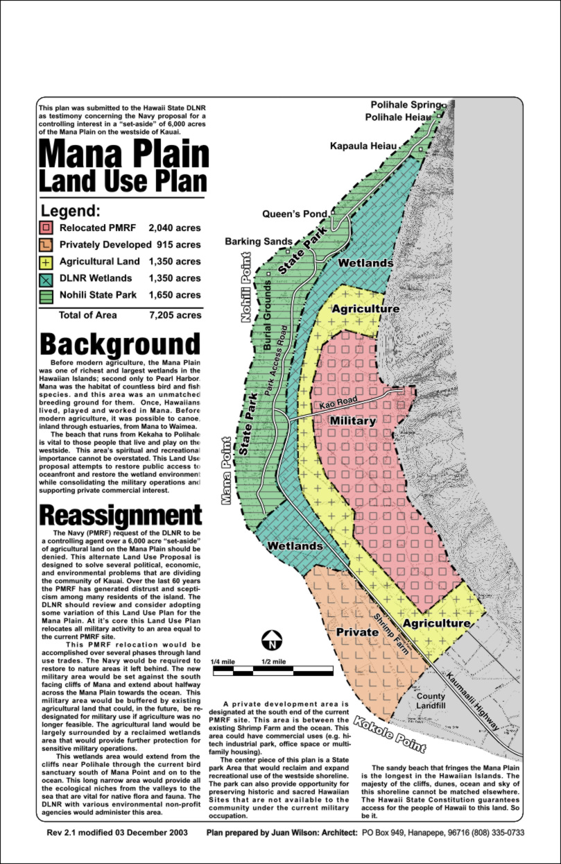
by Juan Wilson 3 December 2003

The following is text from a land use proposal map sent to the State DLNR as part of public testimony in response to the PMRF land use request presented Nov 13, 2003 at Kalaheo Elementary School.

Background on Mana Plain Land Use

Before modern agriculture, the Mana Plain was one of richest and largest wetlands in the Hawaiian Islands; second only to Pearl Harbor. Mana was the habitat of countless bird and fish species. and this area was an unmatched breeding ground for them. Once, Hawaiians lived, played and worked in Mana. Before modern agriculture, it was possible to canoe, inland through estuaries, from Mana to Waimea.

The beach that runs from Kekaha to Polihale is vital to those that live and play on the westside. It’s spiritual and recreational importance cannot be overstated. This Land Use proposal attempts to restore public access to oceanfront and restore the wetland environment while consolidating the expanding military facilities.

Land Use Reassignment Goals

The Navy (PMRF) request of the DLNR to be a controlling agent over a 6,000 acre “set-aside” agricultural land on the Mana Plain should be denied. My Land Use Proposal is designed to solve several political, economic, and environmental problems that are dividing the community of Kauai. Over the last 60 years the PMRF has generated distrust and scepticism among many residents of the island. I request the DLNR review and consider adopting some variation of my Land Use Plan for the Mana Plain. At it’s core my Land Use Plan relocates all military activity to an area equal to the current PMRF site.

This PMRF relocation would be accomplished over several phases through land use trades. The Navy would be required to restore to nature areas it left behind. The new military area would be set against the south facing cliffs of Mana and extend about halfway across the Mana Plain towards the ocean. This military area would be buffered by existing agricultural land that could, in the future, be re-designated for military use if agriculture was no longer feasible. The agricultural land would be largely surrounded by a reclaimed wetlands area that would provide further protection for sensitive military operations.

This wetlands area would extend from the cliffs near Polihale through the current bird sanctuary south of Mana Point and on to the ocean. This long narrow area would provide all the ecological niches from the valleys to the sea that are vital for native flora and fauna. The DLNR with various environmental non-profit agencies would administer this area.

A private development area is designated at the south end of the current PMRF site. This area is between the existing Shrimp Farm and the ocean. This area could have commercial uses (e.g. hi-tech industrial park, office space or multi-family housing).

The center piece of this plan is a State park Area that would reclaim and expand recreational use of the westside shoreline. The park can also provide opportunity for preserving historic and sacred Hawaiian Sites that are not available to the community under the current military occupation.The sandy beach that fringes the Mana Plain is the longest in the Hawaiian Islands. The majesty of the cliffs, dunes, ocean and sky of this shoreline cannot be matched elsewhere. The Hawaii State Constitution guarantees access for the people of Hawaii to this land. So be it.

The land use on the Mana Plain north of the Kekaha Landfill would be as follows.

Relocated PMRF 2,040 acres
Private Development 915 acres
Agricultural Land 1,350 acres
DLNR Wetlands 1,350 acres
Nohili State Park 1,650 acres
Total Land Use Area 7,205 acres

for a copy of the map provided to the DLNR email Juan Wilson


See Island Breath: PMRF Part One for more material and history on this issue.


www.islandbreath.org

Pau

hit tracker /a>