SUBJECT: KAUAI SOUTHSIDE PROJECTS
SOURCE: JUAN WILSON juanwilson@mac.com
A&B
has 3,500 acres it wants to develop on Kauai
12 April 2005 - 8:00am
by Juan
Wilson on 12 April 2005 After swimming we went home for lunch and discovered what Louis had put on the back seat of our Toyota... two annual reports (for 2002 and 2004) from the Alexander Baldwin Inc (A&B). I am not an accountant and bean counting has never been my strength, but there were a few things of interest to me that might interest you. The first thing that was notable was right on the covers of these two reports. A&B corporation has several divisions that fall into three main categories; Agriculture, Transportation, and Property Development. The agricultural holdings include Kauai Coffee; the transportation holdings include Matson Lines and the property development includes Kukui'ula Project in Koloa/Poipu. At one time A&B was a major player in the sugar business. A&B's other business were derived from the wealth accumulated from sugar. Today sugar is not the business it was a generation ago. In fact, of the dozen or so mills once on the island only the Kamakani Sugar Mill is still in operation on Kauai. After looking at the reports my sense is that A&B will be doing a lot of property development here on Kauai in the not too distant future. Just look at the covers. The cover of the 2002 A&B Annual Report shows a montage of five images. All these images take up less than a third of the sky blue cover. The images include a rendering of an Oahu highrise, a closeup of a meal at a waterside restaurant, a portrait of a hardhat wearing heavy equipment operator, a large image of a Matson containership and an an aerial photograph of the land in Koloa/Poipu that will become Kukui'ula. The title of the report is "Shaping the Future".
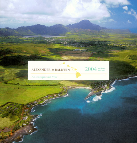
The cover of the 2004 A&B Annual Report has a single image that fills the cover. It is a wide angle aerial view of the Kukui'ula Project site. The title of the report is "An Exceptional Year". Clearly, developing and selling property is one of the few profitable options for A&B if it cannot find a productive use of what were it's sugar cane fields. According to the
2004 annual report A&B owns over 21,000 acres of Kauai. Over 13,000
of those acres are designated as conservation area (primarily higher
altitude inland areas). The bulk of the rest of the property on Kauai
is 7,500 acres that is described as agriculture and pastureland. There
is a small area of 250 acres that is in the category "fully entitled
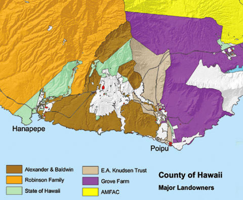
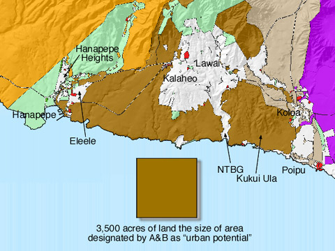
urban". This last category is what could most easily be developed. The property that A&B owns fall into two areas on Kauai. They own most of Wainiha Valley (conservation land) and they control much of the south side of the island not currently used by private homeowners or public agencies. This south side land forms a triangular region (ahupua‘a) on the south side of the island starting at a ridge south of Mount Waialiali and extending along the ocean from Hanapepe to Poipu. This area includes holdings in Koloa, Omoa, Lawai, Kalaheo, Eleele and Hanapepe. Within this area A&B operates Kauai Coffee. This is a moderately successful agricultural business operating on land that was once the McBryde Sugar Plantation situated between Kalaheo and Eleele. Where is the 3,500 acres that A&B sees as potentially an area of urban development?
From what A&B has in the works now and the nature of its holdings it would likely be the areas near existing highways (the main highway and the Numila bypass) as well as areas along the future planned shoreline route from Poipu to Hanapepe. The brown square in the map above represents 3,500 acres (about 4.5 square miles) to scale with the island. The white area of the map is privately held small area properties. and as you can see, the area A&B designates as "urban potential is significantly larger than Hanapepe Heights and Eleele and is about the size of Kalaheo and Lawai combined. The 2004 A&B annual report describes four "near-term" developments on Kauai. Three we have reported on before, Kukui'ula in Poipu, Ka'Olina and Keala'ula in Port Allen. The fourth project is Brydeswood and is described as a 18 lot Agricultural Subdivision on 330 acres of land on the south side of Kauai. It would seen as if the upscale "gentleman farmer" disassembly of agricultural land is beginning on the "westside" in a manner like we've seen on the Gold Coast between Anahola and Hanalei. If you want to keep the quiet nature of island life on the south side of Kauai you should examine what A&B has planned and begin to keep their efforts in line with the Kauai General Plan. Certainly people like Charles Wichman, the Director of the southside's National Tropical Botanical Garden (NTBG) in Lawaikai are worried. Wichman worries that a suburban development of the entire south shore of the island may be created. This will leave the NTBG as the only natural landscape left. A much larger population in the future will put great pressure on the resources of the Gardens.
|
Pau