SUBJECT: KAUAI TSUNAMI
SOURCE: JUAN WILSON juanwilson@earhlink.net
POSTED: 04 JANUARY 2005 - 8:00am.HST
It has and will again happen here
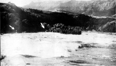
1957 tsunami hitting what was the town on Kalihiwai on Kauai's north shore.
Arrows point to utility poles awash in ocean water
Kauai's recent history with tsunamis The tsunami disaster that hit the Indian Ocean is mind-boggling and emotionally devastating. The scale of suffering in so short a time can only be compared to the attacks on Hiroshima and Nagasaki with atomic bombs in 1945. Total instant destruction! This disaster dwarfs what America experienced on 9/11/2001 by a hundred fold. Compared to the 2004 tsunami in the Indian Ocean the recent history of tsunamis in the Pacific Ocean is insignificant. However, the potential for destruction here is just as real. Hawaii, of course, is in the middle of the Pacific. The Pacific Ocean is rimmed with fault lines from Japan, to the Aleutians, California, Peru, and back around to Indonesia. Tsunamis generated at the rim can take four or five hours to reach Hawaii, with any luck giving us sufficient time to head for the hills.
In my lifetime there have been two significant tsunamis that have hit Kauai. Fortunately for me I was not here for either. Both tsunamis were generated in the Aleutian Islands. The first was in 1946. The major damage from that tsunami was on the Big Island. There is did extensive damage to Hilo, Laupahoehoe and Waipio Valley.
According to www.Pacificworlds.com, "the 1946 tsunami hit with two powerful waves, with a maximum run-up of forty-five feet in elevation. All the bridges at Wainiha were washed out, and the tiny village of Wainiha itself was flattened. At Haena , most of the damage occurred on the flat at the Wainiha end of the ahupua‘a. At least fourteen people died, including many children, and several homes were washed away." They go on to say that "in 1957 seventy-five homes were demolished or damaged along the 15 mile strip between Kalihiwai and Haena -- including 25 of 29 at Haena itself -- leaving around 250 persons homeless. Six Kaua‘i bridges were washed out, including the bridge at Kalihiwai, isolating 1,000 persons on the Haena end of the road. Fortunately, no deaths or injuries resulted from this event."
The following are the heights of ocean inundation, above sea level, reached during 1946 tsunami that hit Kauai. Nawiliwili
9 feet The event we have not prepared for is a tsunami generated in the Hawaiian Islands themselves. A major landslide, above or below the ocean surface, could generate a huge tsunami. Without forewarning such an event would create a wave that would travel from one end to the other of the inhabited islands within minutes, not hours. It is possible
that new GPS monitoring technology could give Hawaii sufficient warning
of earth movements to be useful, but that technology is only being
evaluated now. It has been revealed
only recently how extensive landslides have been in the history of
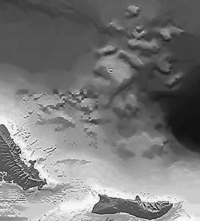
the Hawaiian islands. In the following computer-generated map of Oahu,
the Nuuanu landslide is seen. Debris, amounting to nearly a third
of the island of Oahu, fell off the Windward side. The data was compiled
by J.R. Smith and Terri Duennebier
One thing is clear, the events in the Indian Ocean demonstrate how fragile our lives are living on islands in oceans that occasionally have large ripples.
|
Silent
Volcanic Quakes Could Portend Tsunamis As a result of
the quake, a 2,000-cubic-kilometer section of the southeast side of
the volcano moved seaward, achieving a maximum speed of six centimeters
a day before coming to rest. When the side of the volcano doesn't
halt in such circumstances and instead slips off into the ocean, a
so-called flank collapse occurs. Because of the volume of rock involved,
flank collapses can trigger tsunamis. "This event did not produce
a tsunami," Segall says, "but if we can detect potentially
catastrophic ground motion in its early stages, we might be able to
issue tsunami warnings in the future." |
Pau