SOURCE: JUAN WILSON juanwilson@mac.com
POSTED: 26 May 2006 - 10:00am
Ahukini
- Lydgate Bike Path Project Meeting
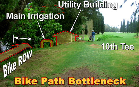
view approaching Wailua 10th Tee with
Kuhio Highway at left and main pump house in bushes
Alternative
Two: The Highway Route Wins the day! The public meeting on the preferred alignment of the Bike Path Right of Way (ROW) from Ahukini Landing to Lydgate State Park (Phase IV of the proposed path) was held at the main Pavilion of Lydgate Park. The meeting began with a brief presentation by Doug Haigh, Kauai County Public Works Chief of Building Division outlining the main features of what he called "Kauai's Health & Heritage Trail", a part of the Mayor's "Shoreline Access Forever" program. The Phases of the project are: Phase I: Lydgate Park (complete) Phase II: Kapaa Lihi Boat Ramp to Kealia Kuna Bay Phase III: Lydgate Park to Lihi Boat Landing Phase
IV: Hanamaulu Ahukini Landing to Lydgate State Park Phase
V: Kuna Bay to Anahola Beach Phase
VI: Nawiliwili Harbor to Ahukini Landing Merle Grimes,
the primary consultant on the development of the Environmental
Assessment, presented the steps he is charged with after the
Environmental Assessment as: He said that all alignment options and comments had been reviewed by Mayor and whole consultation team. He added that the Wailua Golf Course representatives are no supportive of this preferred alignment. Merle then presented the Preferred Alignment of Phase Four. He began with a description of what he believed were major problems that would eliminate some alternative path routes. See article below for our evaluation of the three most likely alternatives. Merle, to a large extent agreed with the "pros" and "cons" as we outlined them. Although
most popular with the county Alternative One: The Shoreline,
was eliminated due to - Alternative Three: The Mauka Solution, was seen as easily achieved but finally eliminated because of the Kuhio Highway crossings. Those crossings could not be achieved with traffic lights because it would slow automobile traffic and because overhead or underground bike/pedestrian crossings would be too expensive. Alternative Two was recommended. The primary problem with Alternative Two is the bottleneck that is formed between the Kuhio Highway and the main golf course irrigation system facility at the Tenth Hole Tee. The available distance between the primary irrigation back-flow preventor and the edge of the highway pavement is a little over 20 feet. In that distance it will be difficult to get a ten foot wide bike path ands the protection needed from the dangers of the highway and the golf course. Merle felt that this bottleneck was short and would be easier to deal with that the shortcomings of the other alternatives. In those areas where the path is near and parallel with the highway and the golf course there will need to be protection for pedestrians and bikers. On the golf course side this will be handled in most cases with a ten foot tall 1" chain-link fence that is disguised with landscaping. Near the highway a crash-proof barrier will be required in some spots. It is interesting
to note that the preferred alignment coincides almost 100% with
the one recommended by the Sierra Club. It is probably the best
compromise that is realistically obtainable. Permits
needed by After Merle's presentation the public made comments and asked questions. These included suggestions that - • existing stands of native plants be protected and future landscaping be don we with native plants • A Shortcut across from the Hanamaulu Railroad Bridge toward the Airport Road be considered for those commuting by bike and that the commuter aspect of the alternative be emphasized • Wetlands and forested areas south end of Nokuliie Coast be avoided in the drop from the cane fields above to Hilton Road • the bike path will be routed in the area of the 12 Hole Tee where flooding occurred this spring and that beyond to an irrigation pond area near Nehe Road. Special construction techniques will be needed. All in all, this was a very positive meeting. |
SOURCE: JONATHON JAY jonathan@dakauai.com
Ahukini
- Lydgate Bike Path Project Meeting
11 May 2006 - 9:15pm
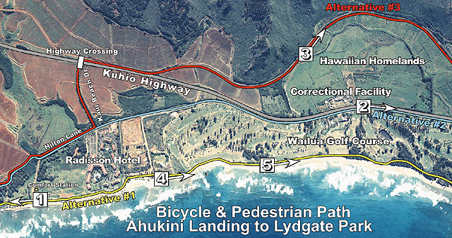
partial view of Ahukini to Lydgate Bike
Path route alternatives along the Nukolii Coast of eastern Kauai
| The final public
meeting for the Ahukini to Lydgate Bicycle and Pedestrian Path will
be held on Tuesday, May 23 at the Lydgate Park large pavilion, from
7:00 PM until 9:00 PM. The agenda will include an overview of the
entire Nawiliwili to Anahola project, a review of the Ahukini-Lydgate
project process to date, and a presentation of path alignment alternatives
and preferences. The Draft Environmental Assessment (DEA) for the Ahukini to Lydgate Bicycle and Pedestrian Path Project is on the County of Kauai web site for your review and comments. Copies of the dEA can also be reviewed at the Kapaa and Lihue Libraries. The dEA has been listed in the Environmental Notice of the Office of Environmental Quality Control on December 8, 2005. You may send comments to: Roxanne MacDougall, Communications Coordinator Box 328, Kapaa, Hawaii 96746 rmacd@aloha.net All comments received will be included in the Final Environmental Assessment report that will be completed in 2006. The comments collected at the third and final public meeting will also be included in the final Environmental Assessment. Questions may be directed to Roxanne MacDougall at 808-822-5798. visit the Kauai government website for more details http://www.kauai.gov/Default.aspx?tabid=335 |
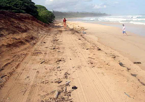
What it feels like on the ground by Juan Wilson on 11 May 2006 On March 12th 2006 Jonathon Jay and I took bikes along the three alternative routes proposed in the map above. It was a cloudy day that proved to be a short break in the 40 days of rain that plagued Kauai at the end of winter. What we found was that each alternate bike route has difficulties, but that routes One and Two have features that are "deal killers".
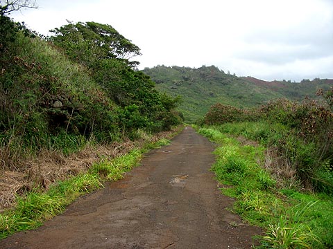
Alternate Route Three (red) proved to be drivable today with no major modification. The only real difficulty in using this immediately as a bike route is the crossing of Kuhio Highway at Kauai Beach Road. We found the ride pleasant, quiet and safe with interesting views of the mountains, wetlands and distant shoreline.
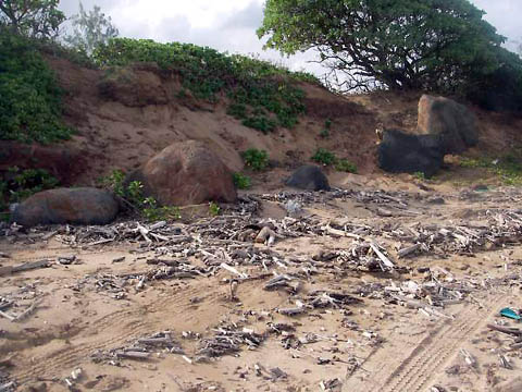
We took Alternative Route Two from south to north and felt it was a great ride until we passed the Clubhouse at the Wailua Golf Course opposite the Kauai Correctional Facility. We found, until then that along the path there were excellent opportunities to provide a bike path away from traffic with peasant views that followed the canal that borders the golf course. However, as we passed the clubhouse and approached the Tenth Tee of the course there was no where for the bike path to go. There was no alternative but to ride into the road. Between the highway and the Tenth Tee there is only about 20 feet. A small utility building is there with a mammoth backflow prevent or that appears to be the main water supply line for the golf course. The condition there makes passage of a reasonable bike path difficult to imagine. The image above shows a group of trees coming right down to the road. In those trees is the utility building and the end of the line for any bike path.
We could not
ride much of Alternative Route One. This is because most of this
path is on sand or dunes along the water. The most infrastructure
would be required to make this path functional for bikes. There
are several critical areas where the proposed path is situated
in areas that are subject to inundation and damage from the ocean.
See image above and note stream washout of dunes in the foreground.
Note also the debris all along and on top of dunes shows winter
surf activity that would threaten any bikeway and possibly riders.
The bikeway itself would be damaging to the dunes and natural
environment at several spots. This areas south of the Golf Course
is considered the "easy" part of Alternative One. The image above was taken along the edge of the golf course south of Hole One. The debris evidence and erosion of the embankment up to the golf course indicates that the area of the bikeway is right on top of the beach and that the normal standards of shoreline setback would place any future bike path up on the fairway itself. Not far further north is even greater erosion and signs that the Golf Course has been dumping fill and rock on the beach to slow the erosion rate.
Obviously, the high wash of the waves pass the rock barrier and are undercutting the fairways already. This means at times there is no beach in front of the Golf Course. The proposed bike path is to be set atop and artificial dune in front of the fairway that will eliminate the beach and be an ill advised seawall for those interested in "saving" the existing layout of the Wailua Golf Course from the inevitable encroachment of the ocean. If one was looking for a bike route that would be ready to go in months and not years, then Alternative Three would be the way to go. Solving the Highway Crossing problem could be solved with a traffic light, bridge or tunnel for a fraction of the cost of Alternative One. |
 2)
View north from Alternate Route # 2 near the Tenth Tee of Wailua
Golf Course
2)
View north from Alternate Route # 2 near the Tenth Tee of Wailua
Golf Course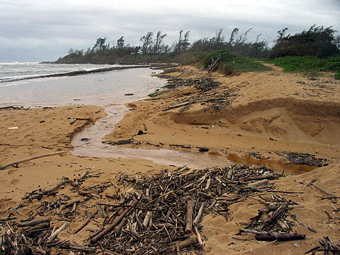
SOURCE: JUAN WILSON juanwilson@mac.com
Biking as transportation or recreation
27
January 2006 - 11:00am
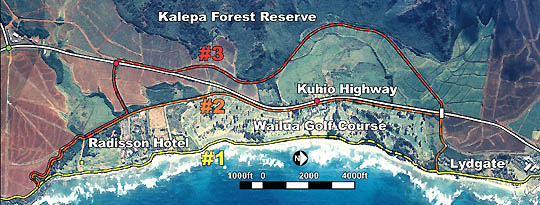
Which bike route is best? Alternative#1 (yellow), Alternative#2
(orange) and Alternative #3 (red)
Conflict
rises between advocates of bike path Maybe we should consider ourselves blessed. We have the opportunity to duscuss route options in the development of a large scale bicycle and pedestrian path that is proposed from Nawiliwili Harbor to Anahola Beach. This stretch of our shoreline is a significant portion of the east side of Kauai. The fact that this is controversial is an indication of how important the issue is. The county government's interest in the path is motivated by goals related to tourism and recreation. A recreational path from the Lihue Airport along the scenic east shore to the beaches and resorts along the Coconut Coast has obvious selling points for those in the "visitor industry". The development of such a recreational feature parallel to the most congested and overdeveloped transportation corridor on the island (Kapaa to Lihue) leads to another important motivation for wanting a bike and pedestrian pathway. One that is closer to the hearts of residents needs than visitors - access and transportation. I strongly advocate the development of an island-wide network of bicycle and pedestrian paths that allow people to travel from Pole Hale to Kee Beach without a car. For that reason I joined with Jonathan Jay to organize "The Kauai Bike Network - Ke Alanui Paikikala" (see article Island Breath: Bike Network). The Kauai Bike Network sees the eastside bike path is part of its overall goal. As the plans for the shoreline bike path have moved forward there has been a tendency for powerful property owners to find fault with the path routing in front of their section of beach and to ask for exceptions that would reroute the path behind them. Certainly, there are places where a beachside path is impractical or unwise. But some cases of selfishness and greed are so obvious and self serving that they damage the heart of the bike path plan. One egregious case is at the future 300 unit Waipoli Beach Resort. Two bedroom condos will be starting at $875,000 in this four story wall of concrete. This traffic snarling mess is across the street from the busy red light at Kauai Village Plaza (where Papaya's Health Food is located). The developer of the Waipoli Beach Resort was able to convince the county planners to route the bike path away from the beach, back to the Kuhio Highway,and around the condos. Since this was an undeveloped and unimpeded site, this was a stupid and damaging decision by the county. It is having unforeseen effects in other areas of the coastline path planning process. The Alternatives [Editors note to mainlanders: mauka means towards the mountains and makai means towards the sea] There have been three major routes suggested to connect Hanamaulu to Wailua. Each have there own variations with attending pros and cons. They are, in order of presentation, Alternative
#1: The Beach Route (yellow) Alternative
#2: The Highway Route (orange) Alternative
#3: The Mountain Route (red) Pros &
Cons Alternative
#1 As a result, the current route for the path the county supports runs on a roadway built-up dune on top of the existing beach. This scheme is makai of all golf course real estate. In effect the bike path would be the seawall the golf course has been unsuccessfully trying to build for decades. Millions of dollars would be required. The State Department of Land & Natural Resources have stated that the path should be at least 100 and preferably 200 feet makai of the certified shoreline in order to protect the beach. This puts Alternative #1 between a rock and a hard place. It is probably a non-starter. Alternative
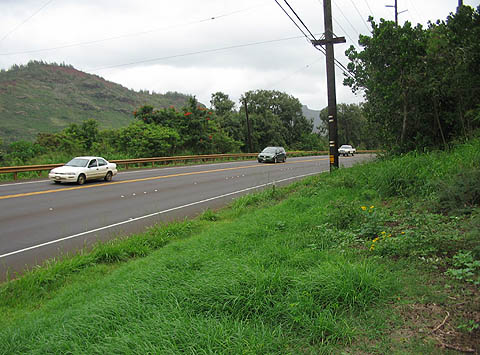
#2 This scheme could fail if this is found to be unacceptable to the golf course power brokers. For example, placing the path on the mauka side of the ditch would put it right on the highway. Noisy, polluted and dangerous--it would not be an amenity for visitors with kids on bikes to be squeezed between high speed traffic (typically over 60mph) and a ditch. Another danger to this scheme is the eventual widening of the Kuhio Highway to four lanes. Alternative
#3 One disadvantage to this scheme is that it is longer than the others and more isolated. Security would be an issue. An added plus to this scheme is it could share a route more in line with a path needed by residents. A need not for recreation and beach access, but for a solution to highway congestion and ever increasing cost of fuel. A commuter bike path between Lihue and Kapaa would be well placed on Alternative #3. This Bicycle & Pedestrian Path is an important and positive thing to be discussing. There are neighborhood meetings and other ways for you to be involved. see also Island Breath: Kauai Bike Network |
Pau