SOURCE: JUAN WILSON juanwilson@mac.com
Design
of Small Dams
31
March 2006 - 4:00pm

by Juan Wilson on 31 March 2006 My wife recently bought me a book from the Talk Story Bookstore that I have been thinking about getting for a couple of years.It was marked at $70 and seemed a high price to pay. The book is "Design of Small Dams" published by the United States Department of the Interior. The book is essentially an engineering manual for designing earth dams.Well, after the failure of the Ka Loko Reservoir we revisited the store and, after being offered a discount, we went home with the book. Incidentally, after checking the web we found Amazon.com offered the book for $99. We got a good deal. The book is not new. It was revised in 1977 and incorporates the engineering knowledge only unto that time. However, the book is still a very useful guide on the design of a number of kinds of dams, including earthfill dams for irrigation reservoirs. The introduction to Chapter 6: Earthfill Dams was written by H. G. Arthur and says in part.
One thing this tells me is that if the the major reservoirs on Kauai were built before 1930 they were built using empirical knowledge that predates the "rational" engineering only developed subsequently. It is unlikely that the Hawaii Department of Land & Natural Resources has the historic knowledge of exactly how those dams were built; their assurances of safety not-with-standing. I think that a prudent thing to do would be to reduce the volume of some of the larger reservoirs by lowering their spillways. This would decrease the likelihood of future massive failures, while continuing to provide water for agriculture. |
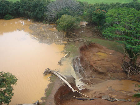
SOURCE: JUAN WILSON juanwilson@mac.com
The
danger may not be over yet!
22
March 2006 - 8:15am

aerial image of lip of Ka Loko Reservoir failure
taken by Jack Harter Helicopters
Unstable
Soil Likely Danger for Some Time I don't claim to have expertise in soil dynamics or hydrology, but I have watched erosion and breaks in soil due to runoff on a small scale along the shore and in the valleys of Kauai. After examining aerial photos of the course of the Wailapa Stream and after interviewing a resident living immediately below the dam failure, I've come to the conclusion that there will likely be subsequent danger to people and the properties downstream from the Ka Loko Reservoir for some time to come. The valley of the stream is as deep as 75 feet in some places. In many areas the 300 million gallons of water that raged down the Wailapa Stream cut vertical walls along the banks of the valley. In some places the torrent washed plants and earth away down to bedrock. In many spots the water cut through deep soil leaving undercut walls, tall cliffs of red earth and what will likely be conditions that will create mud slides, serious erosion and dangerous situations for years to come. The natural repose of un-reinforced soil is about a 100 percent grade (45 degree angle). It is seems likely to me that as following rains saturate the ground, and slice through the embankments with runoff, that the side walls of the Wailapa Stream will calve off large chunks of soil. I predict this action will continue until the natural angle of repose can be achieved and plants can assert themselves again to reinforce the banks. I think that when the unstable sidewalls of the Wailapa Stream collapse they may create situations that create temporary small dams that backfill with storm water and lead to later small flooding situations downstream. This could be particularly dangerous for hikers or others in the valley. I think this could also be dangerous on the high ground above the stream near the embankments. Even moderate loads of something like a moving vehicle along the edge of an embankment that used to be safe, could have disastrous results. I recommend that some testing be done to determine the risks involved and that frequent inspections be made until the danger of aftermath embankment failures subsides. The State and County may already have made these considerations, but I know that some local property owners have not, and may but themselves danger. |
SOURCE:
RAY CHUAN chuan24658@yahoo.com
A
layman’s analysis
22 March 2006 - 8:00am
The
rains of February and March, 2006 |
SOURCE:
JUDY DALTON dalton@aloha.net
22 March 2006 - 7:45am
Dam
Safety: A Quiet Crisis Ka Loko focused public attention on a deeper question we seldom think about until tragedy strikes: What are our government officials doing to keep our communities safe from dam failures? As a general rule, property owners are responsible for maintaining the safety of dams located on their land. State governments are responsible for the inspection of dams (except those owned by the Federal government) within their jurisdictions. However, Congress has an important role in authorizing Federal assistance for dam safety. I have been pressing for Congress and the Federal government to take a more active role in this effort: • Last November, I cosponsored the Dam Rehabilitation and Repair Act of 2005 (H.R. 1105), which authorizes $350 million in Federal grants to states over a four-year period. The grants would cover up to 65 percent of the costs of repair, replacement, reconstruction or removal of unsafe dams. • I am also cosponsoring another bill (H.R. 4226) focused specifically on small privately-owned dams like Ka Loko. It would authorize the Federal government to pay up to 65 percent of the cost of removal or repair of privately owned dams, with a $5 million cap on Federal funds for any one project. The program would not cover dams used to generate power. In addition, I am a cosponsor of the Dam Safety Act of 2006 (H.R. 4981). This bill reauthorizes the National Dam Safety Program Act, a law enacted in 2002 but which is due to expire this year. H.R. 4981 gives a new lease on life to a small but important Federal agency, the National Dam Safety Program. It provides much needed assistance to state dam safety programs in the form of grants, training, research and dissemination of technical information. Also, I am asking for increased funds for the National Dam Safety Program. The Bush Administration has proposed $5.9 million for the agency for fiscal year 2007. I have asked the House Appropriations Subcommittee on Homeland Security to increase the funding level to $8.6 million, the full amount already authorized in law. These actions are fully justified by the huge scope of the need. According to the Association of State Dam Safety Officials, state governments oversee 92,231 dams nationwide (134 in Hawaii). More than 10,000 are rated as “High Hazard” (77 in Hawaii). Ka Loko showed us what can happen when just one of those dams fails. The American Society of Civil Engineers stated in its 2005 Report Card for America’s Infrastructure: “Like all man-made structures, dams deteriorate. Deferred maintenance accelerates deterioration and causes dams to be more susceptible to failure. As with other critical infrastructure, a significant investment is essential to maintain the benefits and assure the safety that society demands.” “Out of sight, out of mind” is a recipe for disaster. The tragedy on Kaua’i underlines the terrifying consequences of ignoring dam safety. Dam failures make the national news, but the root problem is the unseen deterioration that occurs over decades without being repaired. We must do everything we can to prevent the kind of catastrophe that occurred at Ka Loko. You can count on my continuing efforts keep the attention of Congress focused on this important issue. Sincerely, Neil Abercrombie, Member of Congress. Congressman
Neil Abercrombie |
SOURCE: JUDY DALTON dalton@aloha.net
Could
this catastrophe have been prevented?
18
March 2006 - 4:00pm
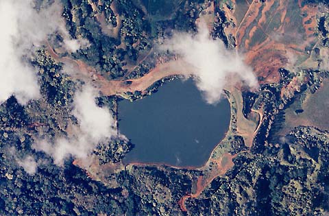
the Kaloko Reservoir in better days. The Wailapa
Stream, the flood course, is to the upper left
|
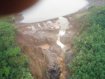
SOURCE: TRACY SCHAVONE tracey@kauaioutcallmassage.com
In
the wake of Ka Loko Reservoir
16
March 2006 - 8:45pm
aerial photo of damaged
Morita Reservoir near the Kuhio Highway.
Photo by Mary Daubert
Sierra
Club's Blue Water Campaign extends sympathy to Kaua`i
|
A
Night to Remember A friend of ours has a home on Waiakalua Road. her property backs onto Wailapa Stream, where 300 million gallons of water passed from the Ka Loko Reservoir devastating homes and families below. Her place is on a tight bend of the stream below the reservoir. As it rounds her property it is a gorge, perhaps 50 feet deep. She was awakened on March 14th by the sound of 75 foot tall trees snapping as the wall of mud and rock scoured the valley down to bedrock. She went out in the dark to see what the thunderous roar was and neared her garden a bit below the upper plateau of her land. Even with a flashlight it was not clear what she was seeing in the beam of her flashlight. Below her feet was a raging torrent but it appeared to ramp up and away from her. To her amazement and horror the turbulent surface of water was climbing the opposite wall of the valley as it banked and tilted around the bend in the stream. It was actually over her head on the far side of the stream. |
for more images of
disaster:
www.kauaiworld.com/dambreak/
for a Flash File simulation
of dam break:
http://gram.eng.uci.edu/~bfs/kaloko_flash.swf
for a WMV
File simulation of dam break:
http://gram.eng.uci.edu/~bfs/kaloko_large.wmv