www.islandbreath.org ID# 0705-13
SUBJECT: KEKAHA LANDFILL EXPANSION
SOURCE: BRUCE PLEAS hisurf3@hawaii.rr.com
POSTED: 22 AUGUST 2007 - 7:00am HST
Comments on DEA for Kekaha Landfill Expansion
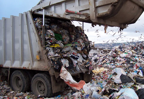
image above: landfills tend to look alike. This one is is in the Castlereagh Borough of Belfast, Ireland
| by Bruce Pleas on 20 August 2007 Section 2.1 "The KLF Phase II is a permitted MSW landfill for the disposal of non-hazardous solid wastes." In section 3.5 it states "The ROI for the hazardous materials and hazardous wastes is the KLF facility." Questions: Where is the disposal site for hazardous waste on Kauai, KLF or where? Section 2.1 is really unclear as to where the hazardous waste is disposed of as it states that it is not at KLF in one part then states it is at KLF in another part. How did arsenic (a hazardous waste) show up in the groundwater? See Section 3.14, page 3-17, which indicates that it came from the unlined Phase 1 landfill. Comment and request: From the above information there needs to be information and facts on Phase 1 landfill and it's effect on the groundwater. Information needs to be presented in the EA on the contents of Phase 1 and the potential hazards to the environment from Phase 1. Section 2.2 Proposed Action Comment and concern: To cap Phase 1 with a base liner system may seem feasible with the right ventilation of the landfill gas from Phase 1 but to me it seems like a plausible scenario for a ticking time bomb of landfill gas. Presently at the KLF there is no smoking allowed due to the constant small of flammable landfill gas on the property. With the capping of Phase 1, the addition of additional tonnage of waste material, rerouted gas and water systems there needs to be a more precise and informative information on the expansion of Cell 3 over Phase 1. Section 2.4.2 Excavation of Phase 1 to construct new subtitle D base liner system This alternative was eliminated due to adverse environmental effects related to excessive odor and gas, landfill fires, and short-term health and safety concerns. Concern: Phase 1 is an unlined landfill that has in one (1) instance already polluting the groundwater with arsenic, from my observations of using the Phase 1 landfill from 1972-1993 there is a greater risk to the environment and public health if Phase 1 is not excavated and moved to a lined landfill. Section 3.1 Air Quality What is presented in the DEA on wind patterns for the KLF is very vague and pretty much completely wrong. The KLF is located on the Mana Plain which does not have predominate Tradewinds during the summer and has very complex wind patterns that need to be identified so that there is a complete understanding of where any contamination will end up or concentrate. On the general summer Tradewind day the winds at the KLF in the early morning will be under 10 knots out of 30-80 degrees (mountain drainage winds), pick up to 10-20 knots out of 70-110 degrees as the Tradewinds fill in thru the morning, die out to 5-15 knots as the direction turns from 70-110 degrees to 180-270 degrees as the land heats up in the late morning/early afternoon, become 10-15+ knot winds from 200-290 degrees thru the afternoon, return to 10-20 knot winds out of 70-100 degrees in the late afternoon if the Tradewinds are strong enough then back down to under 10 knot winds out of 10-80 degrees as the evening mountain winds fill in. This is only one (1) scenario of many that the winds perform on a regular basis at this area. Concern and request: There needs to be a full model of the wind patterns around the KLF for all wind scenarios. Section 3.2 Biological Resources Again what is presented in the DEA is lacking as it only covers flora and fauna that are on the endangered list. Concern and request: What needs to be covered in biological resources are the migratory and resident local birds that frequent the KLF that could possibly either carry any biological material out of the KLF on their bodies or have accumulations of hazardous material in their bodies that could be transferred to the local population of humans. The birds that I have observed at the KLF are Egrets, Mynah birds, Pueo and Pigeons. There are Herons when there is water present at KLF and these Herons are present daily adjacent to the KLF. We do have an increasing Nene population on the Westside on Kauai and these are endangered birds which could make brief stops at KLF. Also there are endangered Hawaiian Coots that are present in the ditches around KLF. There needs to be biological testing of these bird species to find out if these birds have any concentrations of hazardous material building up in there bodies from their contact with the KLF and the adjacent groundwater's. There is no mention of any testing being done on the aquatic species that are in the groundwater ditches adjacent to KLF and in the ocean. This is a big gap in the DEA and needs to be addressed as these aquatic species are being consumed by the resident human population on a fairly regular basis. Some of the species that need to be identified and biologically checked for contaminates are Hawaiian shrimp and Tilapia from the adjacent ditches. Ocean fishes such as Papio, all varieties of Tuna, Ono and Moi that are caught in the ocean fronting the KLF. On the biological testing this needs to be done at least every six (6) months, preferably every 3-4 months, and should also include the local indicator species that will concentrate any contaminates that could be coming from the KLF. To rely only on two (2) water tests per year on contaminates is very inadequate at best to find any contaminates coming from the KLF. Section 3.7 Natural Hazards Floods "...the KLF facility is within a FIRM Zone X, an area determined to be outside the 500-year flood plain." Observation and request: Over the last 35 years I have seen the main road impassable to motor traffic at least once (around 1980) and have seen the present Phase 2 location under water at least 5 times before the landfill was constructed, at which times you could not access Phase 1 due to an impassable dirt/gravel road leading to the Phase 1 site. Almost every year the fields adjacent to the KLF are flooded with the crops basically destroyed by sitting in water for any where from a day to a week in the lowest areas. The records from the seed companies should provide data on this as they do lose crops during these floods. I agree that the KLF mounds are out of the 500-year flood but to say that this area does not flood is completely wrong. Also there needs to be some investigation as to what the groundwater flow is during these flood events as they may bring the groundwater level above the height of the plastic liner of the Phase 2 landfill. Tsunami Request: There needs to be a study on what will happen in Tsunami scenarios that range from a minimal Tsunami (historic size that happened around the 1940-1950 era), a moderate Tsunami that is the same magnitude as the Indonesian Tsunami a few years back and a major Tsunami that is generated locally (probably from the Big Island). This study should address the ability of KLF to sustain all levels of Tsunami inundation, what are the probable consequences and what will need to be done after the Tsunami to contain the hazardous materials that could be released if the KLF is damaged or destroyed. From what I understand the 1940-50 Tsunamis reached the base of the Pali in some areas, a Tsunami the size of the Indonesian Tsunami reached the 100' above mean sea level in some areas and a Tsunami from the Big Island could completely wipe out the KLF along with all coastal areas of Kauai. Section 3.11 Transportation "Traffic along Kaumualii Highway is usually light and use is most commonly associated with Polihale State Park and federal reserve lands." Comment and request: The above statement is very misleading and seems to indicate that minimal traffic is present on Kaumaulii Highway. Polihale State Park is visited by a large amount of visitors and residents (figures are available from the State Highways and Tourist Departments), PMRF is one of the largest employers on Kauai and has in excess of six (600) vehicles entering and exiting per day. These figures and the affect of all traffic on the towns of Kekaha and Waimea need to be included in the EA. From the public testimony at the DEA meeting at Waimea on August 9, 2007 there was great concern on the speed of the trucks thru Kekaha and the amount of trash being blown out of the trucks using the KLF with these concerns also needing to be addressed. Section 3.13 Visual Resources Comment and request: KLF is visible from the ocean from as far away as Kaumakani to the east and PMRF to the west which is around 3-7 miles. This needs to addressed as the ocean adjacent to KLF is the main route of tour boats to the Na Pali coast. The Kauai General Plan has designated Kaumaulii Highway as a "Scenic Roadway Corridor" which is addressed in Sections 3.2 and 5.5 in the Kauai General Plan. Since the KLF is partially visible at this point and will become more visible as it grows and expands there needs to be a plan to bring the KLF into compliance with the Kauai General Plan. Section 3.14 Water Resources Surface Water "Runoff from the top of the closed Phase 1 of the KLF landfill flows radially off the landfill ..... discharge to an infiltration ditch...." Comments and request: Phase 1 deeply concerns me as the top pf Phase 1 is used as a storage area, with any runoff from the top of Phase 1 potentially containing contaminants from the "white goods" stockpiled there on dirt. Is the infiltration ditch around Phase 1 lined or is it just allowed to percolate into the groundwater? An in depth study needs to be done on Phase 1 runoff that includes all scenarios and levels of runoff from various sources like rainfall from normal weather, exceptionally wet periods (2006) or Hurricanes. The surface water data is lacking in any map/chart that defines the direction, amount and quality of the groundwater that surrounds the KLF and what happens to the groundwater during the wet/flooding episodes. Groundwater Comments and request: The groundwater data is very vague ("estimated or from a single monitoring report") and there needs to be a complete study on the groundwater flows during all scenarios. This would include the amount of groundwater that flows into the ocean at all areas adjacent to the KLF and the possibility of any groundwater reaching Kekaha. Since Phase 1 is an unlined landfill there needs to be specific attention given to Phase 1, especially since Phase 1 is the closest to the ocean and areas used by residents (beach and drag strip). Section 4.1 Air Quality "Once collected, the gasses are burned in a flare where...." Comment and request: No mention of burning the landfill gas for energy and no mention of the affect of landfill gas (23x CO2) on the earth's environment. Both of these need to be addressed along with the complete identification of the wind patterns for the KLF and Mana Plain area. Section 4.2 Biological Resources Comment and request: This section is a complete flop and needs to be redone. Where is the consultation from the USFWS? Should it not have be included in the DEA? Following is a copy of what I proposed in Section 3.2. What needs to be covered in biological resources are the migratory and resident local birds that frequent the KLF that could possibly either carry any biological material out of the KLF on their bodies or have accumulations of hazardous material in their bodies that could be transferred to the local population of humans. The birds that I have observed at the KLF are Egrets, Mynah birds, Pueo and Pigeons. There are Herons when there is water present at KLF and they are present daily adjacent to the KLF. We do have an increasing Nene population on the Westside on Kauai and these are endangered birds which could make brief stops at KLF. Also there are endangered Hawaiian Coots that are present in the ditches around KLF. There needs to be biological testing of these bird species to find out if these birds have any concentrations of hazardous material building up in there bodies from their contact with the KLF and the adjacent groundwater's. There is no mention of any testing being done on the aquatic species that are in the ditches adjacent to KLF and in the ocean. This is a big gap in the DEA and needs to be addressed as these aquatic species are being consumed by the resident human population on a fairly regular basis. Some of the species that need to be identified and biologically checked for contaminates are Hawaiian shrimp and Tilapia from the adjacent ditches, Papio, a variety of Tuna, Ono and Moi that are caught in the ocean fronting the KLF. On the biological testing this needs to be done at least every six (6) months and should also include the local indicator species that will concentrate any contaminates that could be coming from the KLF. To rely only on two (2) water tests per year on contaminates is very inadequate at best to find any contaminates coming from the KLF. Section 4.7 Natural Hazards Comment and request: The "Proposed Action" paragraph is inadequate to address any of the Natural Disaster scenarios. The storm surge from a Hurricane should not reach the KLF but the area adjacent to the KLF will flood, the storm surge and the increase in the surface/groundwater level could affect the integrity of the Phase 2 plastic barrier and since Phase 1 is unlined it just goes wherever it wants with the storm waters. As for the coastal dunes (all under 12' above MSL) dampening the affect of a Tsunami it may well happen that way with a minimal Tsunami, but with a moderate to severe Tsunami the coastal dunes will be of little protection and again Phase 1 just sits there close to the ocean with no liner. Also there is no mention of Global Warming and the possible rise of sea levels which would affect the KLF since it is only a few feet above sea level. This section needs to be updated and have solid information on the affects of any and all natural disasters that could affect the KLF. Section 4.13 Visual Resources Comments and requests: Presently the KLF is visible at around sixty (60+) feet above MSL and with the doubling of the KLF area and a final height of eighty-five (85) feet it will be very visible from the ocean and mauka areas, visible from the adjacent coastal areas. Also there is no way in #### that you can make the KLF blend in with the dunes as they are only ten (10) to twelve (12) feet high and are made out of white to tan sand while the landfill is brown dirt. Even to plant it with vegetation is questionable due to the amount of landfill gas that will be present in the area. This landfill will have a permanent affect on the quality of the visual life on the Westside of Kauai. Section 4.14 Water Resources Comments and request: To put a liner over Phase 1 and then say that it will reduce the affect of Phase 1 on the water resources may be true to some extent but the overall effect of increasing the area and height of the KLF has the potential to greatly affect the water resources of west Kauai and the ocean. Presently and in the proposed expansion of the KLF there is only water testing being done on a semi-annual basis in an area that the groundwater is found from 2.5 to 5 feet above MSL (From Section 3.1, page 3-17) and from this figure of where the groundwater is in relation to the general height of the land above MSL (mostly under 12' above MSL) there is the need for a more comprehensive study and information on where and in what volume the groundwater moves during all scenarios. Also in the DEA it is not clear as to the current acreage volume and the proposed acreage and volume of the "leacheate and infiltration pond" areas. With the doubling of the KLF there needs to be complete information on the current and proposed "leacheate and infiltration pond" areas. Section 5.1 Significance Criteria I have listed the "Bullets" in numerical order with my comments on each bullet (refer to previous testimony as needed): 1) The expansion could have adverse impacts on biological resources, cultural resources and water resources due to the fact that the water studies are incomplete and do not cover all aspects of natural disasters and have not performed biological studies of the local bird and fish population. 2) The KLF facility will not be expanded but it is still questionable as to whether this parcel of land will be able to hold this increased amount of solid waste without a degradation of the local environment, especially after a natural disaster. 3) Why a landfill was first located within an SMA, a Conservation area, a Tsunami zone, in a plain that has the groundwater so close to the surface and so close to the Pacific Ocean is a mystery to me. Now to pile more waste on a small area it is questionable to me that this sandy area can hold the tonnage of waste that is being proposed. This site has conflicted with the State policies since the beginning and will continue to conflict with the State policies as long as it exists. 4) This area was the "Garden of Kekaha" before the landfill was located there with many residents obtaining "Lei material" and "Cultural materials" from this area along with fishing and hunting in the entire area. The KLF has affected the economic, social and cultural practices of the community from the beginning of the operation and will continue to affect these practices for a as long as it exists. 5) To say that the KLF will have long term positive affects on Kauai is true, but it will continue to have negative short and long term affects on the Kekaha community in the form of potential air, water and resource pollution from a continuing operation and the proposed expansion. The amount of cancer on the Westside of Kauai is high and this is from a combination of unregulated agriculture operation (Industrial agriculture--Genetic and Herbicide research), old landfills (under Kekaha Gardens Subdivision) along with the contamination of the groundwater from 1,000+ septic systems sitting in the groundwater. KLF is just another small portion of the contamination of the Westside groundwater table that could be a major portion in the advent of a natural disaster or the failure of the protective membrane. 6) The secondary impacts such a population change will be minimal and the effect on public facilities will also be minimal. It could be a positive effect on public facilities with the proposal of a landfill energy production facility, but that is not mentioned in the DEA so that rules out a positive impact at this point from the KLF. 7) Do we have to go over this again? Just a short comment, the quality of the environmental study in the DEA is very lacking and to state "Per the analysis in this EA, the proposed Phase II lateral expansion would not cause any impacts that would degrade environmental quality." is unsubstantiated in my view with out any quantitive figures on biological testing, health of the local human population and water flows. There also needs to be a solid definition of the phrase "substantial". 8) To say that a population center (Kekaha) less than 2 miles from a landfill area that sits in the same groundwater, is susuptible to a number of different natural disasters and structural failures with no contingency plans in place for these possible scenarios will not have a cumulative effect on the environment is not true. 9) There are minimal to no endangered species within the footprint of the KLF but there are endangered species adjacent to the KLF that will and are being affected by the KLF. There is an impact happening now and it will increase with the bigger KLF. 10) The air quality has not addressed the amount of landfill gas being released into the atmosphere, the carbon footprint and cost to the State in carbon emissions and the possibility of an energy producing facility that would decrease the amount of landfill gas being released into the atmosphere. The water quality issue has not been addressed fully in the DEA and to state that "Therefore, detrimental affects to water quality are not anticipated." is meaning less. 11) The KLF is located in all of the environmentally sensitive areas listed such as a flood plain (Mana plain was and still could be water from Waimea to Polihale), it is in a Tsunami zone, the beach is presently 1,400 feet away and with global warming and the ocean rising who knows where the beach will be in 2010 (information will be available from the County Erosion Study in the near future), erosion-prone area geologically hazardous land and estuary it is not at this point, it is lying in a freshwater area with just ditches and pumps keeping it dry presently and is adjacent to coastal waters with an undetermined amount of groundwater flowing into the ocean daily. 12) It does affect the scenic view from the mountains and ocean, will affect the scenic view from the Mana plain when it is finished and marginally affects the view from the "Scenic Corridor" presently. 13) The KLF should be an energy producing facility. Section 5.2 Determination The finding of a FONSI is not accurate from my point of view as the DEA has insufficiently addressed many important aspects required in an EA. contact: |
SUBJECT: KEKAHA LANDFILL EXPANSION
SOURCE: BRUCE PLEAS hisurf3@hawaii.rr.com
POSTED: 7 JULY 2007 - 9:00pm HST
Public meeting set for Kekaha Landfill
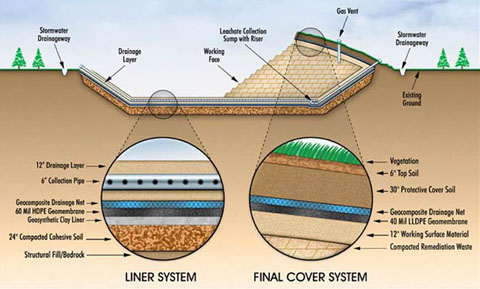
image above: typical cross section of modern landfill
WHEN: CONTACT: fax: 808-523-8874 |
SUBJECT: KEKAHA LANDFILL EXPANSION
SOURCE: BRUCE PLEAS hisurf3@hawaii.rr.com
POSTED: 25 JULY 2007 - 5:00pm HST
County schedules no public meetings
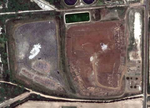
image above: GoogleEarth view of Kekaha Landfill: Kaumualii with Highway at right
by Bruce Pleas on 24 July 2007 Mayor Brian Baptiste, On page 6 of the Environmental Notice from OEQC (link provided below) is the proposed expansion of the Kekaha Landfill with public comments due by August 22, 2007. My question is why is there no COUNTY PUBLIC MEETING SCHEDULED FOR THE KEKAHA NEIGHBORHOOD CENTER to present this proposal to the community of Kekaha so that they are aware of this project and the requirement that public comment is due by August 22, 2007? OEQC link http://www.hawaii.gov/health/oeqc/notice/current_issue.pdf Below is the text of the OEQC notice regarding the Kekaha Landfill.
|