[Editor's
Note: Normally these columns are scheduled to appear every other
Sunday.The final published version may vary from this text as TGI
retains the right to correct and edit the material. The
copyright to the published version is held by TGI owner Kauai
Publishing. Some material in TGI columns may have appeared on
www.islandbreath.org already]
Island
Breath: Moku, Kalana & Ahupuaa
by Juan Wilson & Jonathan Jay published in TGI on 17 June 2007
Revision 6.0-070613
special to the Garden Island News © 2007 by Kauai Publishing
AN ENVIRONMENTAL MAP OF KAUAI
As colleagues we have been developing a base map to used for planning
representing environmental regions of Kauai. Our goal is to respect
the traditional Hawaiian system of Ahupuaa and bring a time-tested
perspective to today’s effort of land management and governance.
In researching historic maps of Kauai we have found differing evidence
of what was the "Hawaiian Way". After some study, we realized
that (like an onion) there are several nested layers of organization
to the Hawaiian system:
Hawaii Nei - The entire inhabited island group
Mokupuni - The island groups (like our current
county system)
Moku - The major districts of each individual island
Kalana - The significant divisions within each
Moku
Ahupuaa - Individual watershed regions within each
Kalana
Ili - functional subdivisions of an Ahupuaa
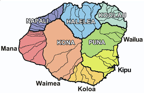
WHAT WERE KAUAI'S HISTORIC DISTRICTS?
Today, convention lists five Moku regions of Kauai: Na Pali, Halelea,
Koolau, Puna, and Kona. However, this was not always so. Maps from
as far back as 1820 tell a different tale with as many as six Moku.
Some maps from the later 1800’s and early 1900’s show
as few as three. Evidently, there were either different understandings
of what the districts were, and/or the districts changed with the
political changes that have swept Hawaii. Perhaps when there was
self-rule on Kauai, a greater understanding of our aina resulted
in a greater diversity of regions, while external rulers, ‘consolidated’
for the purpose of ruling from afar.
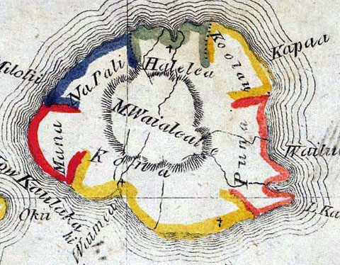
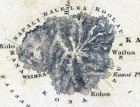
map above: detail of Kauai in 1837 map by Kalama.
For whole map and more of Hawaii visit http://www.davidrumsey.com/luna/servlet/detail/RUMSEY~8~1~192~10176
Also interesting is that the first map of Hawaii done by a Hawaiian,
in 1837, shares a feature with several other early maps: the Moku
districts do not extend “from makai to mauka” to meet
at the center of the islands. They are mostly restricted to the
coast. The central region of the island remains open and undelineated.
In our last column we wrote about these mountainous interior regions
as Kua, or God's country. Perhaps as in today's current forest conservation
areas, this was considered a common area considered to be ‘out
of bounds’.
map above: detail of Kauai in 1845 map by Charles Wilkes for U.S. mapping expedition
Although there are many differences with the details of Moku on Kauai,
most maps consistently show four broadly descriptive district names:
"Koolau" - which means "windward", "Puna" - which means "spring of
water", “Kona” - means “leeward”, and Na Pali - that means “the
cliffs”. By ‘broadly descriptive’ we mean that these region names are
not exclusive to Kauai, but appear on more than one of the other
Hawaiian Islands. Hawaiians quite simply “called 'em like they saw ’em”
with the windward area of the island, being called: “Windward.” It is
hard to argue with that.
FAST FORWARD TO TODAY
Today Kauai is chopped up into Tax Map Key districts by the logic of
the marketplace. With the TMK the main intent is to identify who owns
the land and how to collect revenue from it. From a Hawaiian or
environmental view, this is rather upside down – everything begins with
the land.
For our map we started with the five Kauai Moku now widely accepted -
Kona, Na Pali, Halelea, Koolau and Puna - and harmonize with the
contemporary political and social realities.
Because “Kona” is almost half of the island, and "Puna" has almost half
the population, we feel that they would each be better managed and
represented if divided into smaller districts, or Kalana. Although
there are no historic maps that show a division of Puna into Kalana,
there are maps that show Kona divided either from Mana or the Koloa
southside area: Hence the Kalana of Mana, Waimea and Koloa.
We chose the southern border of the Wailua watershed to divide Puna. It
seems a logical place and there are no existing communities that would
be split. The result, the Kalana of Kipu and Wailua. Of the eight
districts, Na Pali is the only one virtually unpopulated, but all are
reasonably sized and separate in their distinct environments:
These choices led us to design the map at the top of the article:
| MOKU - Kalana |
AREA |
POPULATION |
| NA PALI |
32 sq miles |
200 people |
| HALELEA |
91 sq miles |
4,000 people |
| KOOLAU |
43 sq miles |
7,000 people |
| PUNA Wailua |
80 sq miles |
6,000 people |
| PUNA Kipu |
56 sq miles |
13,000 people |
| KONA Koloa |
41 sq miles |
10,500 people |
| KONA Waimea |
149 sq miles |
12,000 people |
| KONA Mana |
63 sq miles |
2,500 people |
| TOTAL |
555 sq miles |
65,200 people |
Looking
to how the Hawaiians managed the land will be increasingly useful as we
strive for a self-sufficient sustainable life on Kauai. If the people
of Kauai keep a seven person County Council to manage the island, these
seven populated districts could be the basis of Council representation,
with Na Pali as a commonwealth area, shared by all. Future governance
may even be by an Ahupuaa Legislature representing the many individual
watershed based communities of Kauai.
We are not saying our suggestion is a "final answer" - it is an
interpretation. Any new way of looking at Hawaiian tradition and county
government will likely create turmoil. But look at them we must. Our
hope is that a new and vital discussion begins, and that the aina be a
part of it.
We will be posting an evaluation map of Kauai environmental districts
and more detail on the smaller Ahupuaa, as well as regional community
centers on the website.
|