Another way that water has played a critical role in determining what we see around us today in Panama is the cycles of the Ice Ages. About 10,000 years ago, Panama was locked in a glacial epoch that buried virtually all of New York under hundreds and, in some places, thousands of feet of ice. It was not until 1837 that a proposal for a prehistoric ice age was presented. Louis Agassiz presented such a scientific theory to the Swiss Society of Natural Science. It was not long afterward, in 1842, that an astronomical theory was formulated that explained why there might be periodic cycles that resulted in glacial and interglacial periods.
Joseph Alphonse Adhemar, a Frenchman, published "Revolutions of the Sea". He based his theory on Johann Kepler's model of the solar system that specified the elliptic orbit of the earth (about one degree of eccentricity), and the angle of the earth regards the plane of the orbit (about 23.5 degrees). Adhemar pointed out that the angle of the Earth to the plane of its orbit wobbled like a top, on a 26,000 year cycle.
At some times the angle of the Earth was as little as 22 degrees, and at other times as much as 25 degrees. More importantly, the elliptic orbit itself rotated around the Sun on a 22,000 year cycle. Adhemar postulated that at those times when the northern hemisphere winter solstice occurred when the earth was farthest from the sun would be a time of maximum glaciation.
The Scottish geologist, James Croll, used this astronomical model and historical data to plot the cycles of past and future ice ages. In 1875 Croll published "Climate And Time". He hypothesized that when the angle of the Earth's tilt was least, the glaciation would be more severe. There was much debate about these predictions, but refinements of these theories are currently held by todays geologists and astronomers.

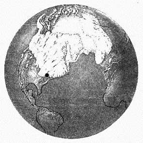
The Earth's northern icecap as it appears today
Drawn by Anastasia Sotiropoulos from CLIMAP project data 1976
Note: Black dot denotes Panama New York
At the present time, we are about as close to the sun as possible during winter. That's about 11,000 years from the time at which we were far from the sun and there was deep glacial ice covering most of New York. Geologists now think the course of the Missouri River and the Ohio and Allegany Rivers mark the southern edge of the last ice sheet. The Mississippi was basically a drainage ditch for the retreating glacial cap.
The images on this page show the current ice cap (above) and the deepest penetration of ice southward in ancient times (below). Note that locking all this water up as ice dropped the world ocean levels 350 feet..down to the continental shelves.
The Earth's as it appeared during maximum glaciation
Drawn by Anastasia Sotiropoulos from CLIMAP project data 1976
Note: Black dot denotes Panama New York