Recent image of Earth's southern ice cap from space
The Last Glacial Maximum
Recent image of Earth's southern ice cap from space
The Last Glacial Maximum
by Juan Wilson ©1999 The Gobbler: Autumn Feast (revision 1.1) It started with a trip to the Ellicottville autumn festival a few weeks ago. A friend, Chris, mentioned we ought to stop, on the way , in Little Valley, New York to see a place called "Little Rock City". It's on McCarthy Hill in Rock City State Forest. This is a formation of conglomerate quartz rock that breaks through the surface of a gentle hillside on State forest land. The conglomerate rock is about 20 feet deep and broken through by fissures that separate the rock into flat topped "islands". You can jump from one island to another in several locations. It's sort of like a giant oatmeal cookie, a quarter mile wide that's been dropped and broken on the landscape.
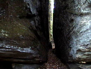
Tight alley in Little Rock City in Little Valley, New York
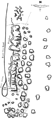
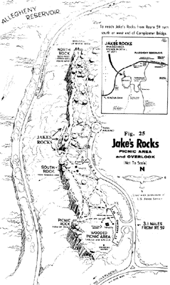
My part of the world is no stranger of this kind of conglomerate rock. There are several exposed formations within an hour's drive, but I'd never visited the one in Little Valley. We call them "Rock Cities". They stretch, more or less, east to west, following the path of the Allegheny River Basin. Two of the most dramatic are "Big Rock City" in Olean, New York and "Panama Rocks" in Panama, New York. There's also "Bear Caves", in Allegheny State Park, "Jake's Rocks" in Allegheny National Forest in Pennsylvania, and several others that are well documented in "Secret Places: Scenic Treasures of Western New York and Southern Ontario" by Bruce Kershner, Kendall Hunt Publishing, 1994.
In fact it was this book that started me on a course that has brought me to writing this article. While we were at Little Rock City Chris mentioned that it was the lack of glacial ice during Ice Age that was responsible for the existence of the Rock City formations along the Southern Tier of New York. He was referring to material in the "Secret Places" book. I was surprised. I live in Panama a mile from Panama Rocks and had thought that the glaciers of the last Ice Age had stacked a quarter mile of frozen water in my front yard 10,000 years ago. I argued that case and a day or two later Chris e-mailed me a quote from Bruce Kershner's book. Among other things he wrote...
"Remember to "thank" the Ice Age glaciers for giving us the opportunity to see these remarkable rock formations. All of the rock cities lie just south of where the Ice Age glaciers stopped 12,000 years ago before melting away. If the glaciers had continued south, they would have obliterated the rock cities, grinding some of the boulders into oblivion and scattering the rest over the land. "
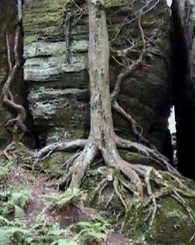
The Eagle's Claw formation at Panama Rocks
My first thought was to check The Panama Rocks Website (www.panamarocks.com) and see if there was a description there of the rock formations. There was and it went like this...
"Over 300 million years ago, the Panama Rocks were Sea Islands of sand and gravel, along the shore of a vast inland sea that extended west toward what is now Utah. These islands were part of the delta of a great river, larger than the Mississippi. What remains of that delta extends from the Allegheny River toward Lake Erie, and from eastern Ohio into southwestern New York.
The Panama Rocks are a sedimentary type of rock, composed of particles deposited by that ancient river. Layer after layer was deposited, until thousands of feet of sediments covered the original Sea Islands. The weight of these deposits caused "pressure compaction". The water was driven out, and due to the composition of the materials, a natural form of concrete was created. This type of rock is known as "quartz-conglomerate", and it is sometimes referred to as "pudding stone". Some books refer to this as the "Panama Conglomerate". Stones embedded in this rock are oval and rather flat, due to the water action [wave action] they experienced when they were on those ancient Paleozoic beaches. These embedded stones are primarily quartz (white), spar (pinkish amber) and flint (tan).
Approximately 165 million years ago, there was great geological activity [earthquakes, etc.] on what are now the east and west coasts of North America. Block-faulting and uplifting occurred. It is believed that the layer of rock that became the Panama Rocks was raised to its present altitude [1650'] at that time. After this rock layer had been fractured, seepage of water through overlaying sediments carried minerals [iron, lead, etc.] in solution, and deposited them in the fractures in the rock below. [Indians obtained lead from a site in the rock formation and sold it to settlers. In 1985, pieces of naturally formed lead were found in the park using sophisticated metal detectors.]
The present day Panama Rocks formation was most dramatically affected by a glacier in the last Ice Age, about 10,000 years ago. The weight and pressure of the glacier accelerated widening of fractures in the rock, creating thousands of crevices and alley passageways. When the glacier melted, this unique rock outcrop was first revealed. Eventually a forest grew over the site. The Panama Rocks are reputed to be the most extensive formation of glacier-cut, ocean-quartz conglomerate in the world. The ridge is approximately 1/2 mile long."
This last paragraph sounded as if the glaciers sat right on top of Panama Rocks (and consequently my yard) and that their weight and later erosion from their meltdown, were responsible for the unusual conglomerate formations. This was a direct conflict with Bruce Kershner's theory. I called Craig Weston, the owner of the Rocks and author of the website, what his paleo-geologic sources were. He said he had put together the information he had collected from several geologists that had visited the Rocks and spoken with him.
My next thought was to go back and read a Gobbler article (The Ice Age Cycles) from 1993 that included an illustration, by Anastasia Sotiropoulos, of glacial coverage over North America during the last Ice Age. The source of data for the illustration was published in 1976 through the CLIMAP project at Columbia University. The illustration seemed to show this part of western New York under the ice, but that was not as clear enough to be indisputable. I felt that newer theories and data might contradict the best opinion of a quarter century ago.
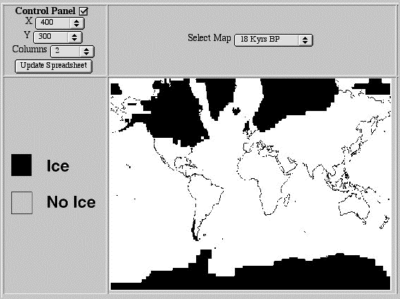
I searched out CLIMAP on the WEB and found that the data was updated in 1996 and is now supported by Columbia University on the WEB at The CLIMAP Data Set (http://ingrid.ldgo.columbia.edu/sources/.climap). This website allows the user to specify any geographic location on earth and display glacial extent of 18,000 years ago and compare it with glaciers today. The Last Glacial Maximum is identified as 18,000 years ago. This was much earlier than the 10,000 to 12,000 years ago that I remembered from my time in school.
This CLIMAP reconstruction of the glacial extent is based on Paleo surface temperature for this dataset is calculated using principal component analysis. This method involves quantifying the relationship between species abundances and sea surface temperature.
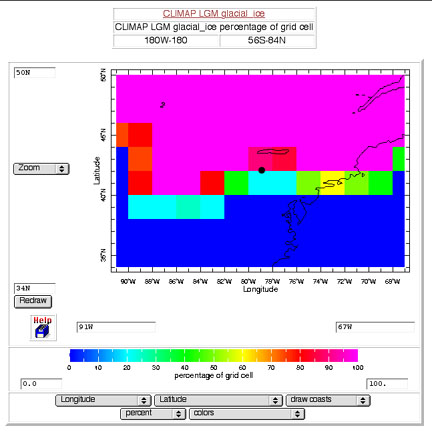
Northeast US maximum glaciation 18,000 years ago
Website visualization from CLIMAP project data 1996 showing percentage likelihood of ice cover within ~100 mile grid
Note that in the illustration above that I set the WEB site to center on the location of Panama, New York (79 degrees west and 42 degrees north). After downloading the image I placed a black dot at Panama. As it turns out the location of Panama is right on a break in the database grid. I zoomed in by a factor of four and the grid split was even more precisely centered on Panama.
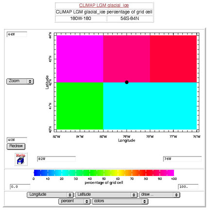
Detail of Western NY centered on Panama
Website visualization from CLIMAP project data 1996 showing percentage likelihood of ice cover within ~100 mile grid
It might have been the shore of an island in a tropical sea millions of years ago, but 18,000 years ago was another story. To the north is a redish-magenta grid square with a likelihood of surface glaciation of 85-90%. To the south is a cyan-blue grid square with a likelihood of glaciation of 20-25%. In other words, 18,000 years ago the CLIMAP data indicates that Panama was statistically right on the edge of a sharp differentiation between misty alpine evergreen forest and thousands of feet deep of frozen crushed ice.
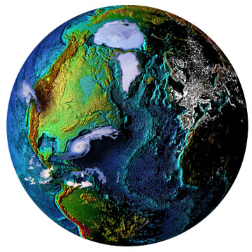
National Geophysical Data Center website illustration
There is also the World Data Center for Paleoclimatology in Boulder, Colorado with a website at National Geophysical Data Center (www.ngdc.noaa.gov/) which is part of the National Oceanic and Atmospheric Administration . Among other features the website features a page pointing to Paleoclimatology Reconstructions (www.ngdc.noaa.gov/paleo/recons.html).
There you can visit a visualization of the the Peltier Ice Dataset (www.ngdc.noaa.gov/cgi-bin/paleo/peltice.pl) . Peltier uses another technique, involving variations in planetary gravitation, to reconstruct the compression of the upper mantle of the earth by the weight of the Ice Age glaciers.
Display from WEB of W. Peltier Last Maximum Glaciation 18,000 years ago
This model indicates the extent and depth of ice in the years between 21,000 years ago and the present. The Peltier reconstruction indicates that the LGM occurred about 18,000 years ago and was of about the same extent of the CLIMAP data, but predicts that there was about 35% less depth of ice than in the CLIMAP reconstruction.
What does all this mean? The most authoritative sources think that the Rock Cities of the Southern Tier of New York were right at the southern boundary of the last maximum glaciation about 18,000 years ago.
Geologic history indicates that a layer of conglomerate rock about a hundred feet deep extended east and west from Ohio through much of the Southern Tier of New York. In this area it was relatively flat and level at an elevation of about 1650 feet above sea level.
After visiting these WEBsite databases I went back to the "Secret Places" book and realized that all the "Rock Cities" shared a remarkable common feature besides a thick flat layer of conglomerate rock broken up like a giant oatmeal cookie... they all ran north and south. This is true of Panama Rocks as well.
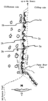
Little Rock City Jake's Rocks Bear Caves This north-south orientation is clearly perpendicular to the general edge of the glacier front. This data reviewed here indicates to me that that a towering wall of glacier ice once ran east west just north of this table of conglomerate rock. Consequently, I no longer believe it was the glaciers sitting on top of the Rock City locations, eons ago, that created their odd formations. I don't think they were formed by direct erosion of melting glacier water running over the top of them either.
For many years I lived near the ocean. On many occasions, after a high tide, I've seen long pools of sea water trapped just behind the hump of sand that separates the ocean from land. As the tide ebbs and the pool begins to drain the flow of water usually cuts a wide and shallow path through the crumbling sand. On either side of the flow the sand had vertical wall that are delicate. Chunks of the wall crack off and are swept down to the ocean. I think that something like that happened when the glaciers were melting.
The glacier stopped just north of the Rock City sites. When it melted, it was turned into billions of tons of water that flushed and scoured away much of what was to the south. At the edges of rushing water were places that were not scoured away. It seems to me that these new riverways must have cut swaths through the crumbly conglomerate leaving vertical cliffs in some of those places that were not swept away.
In the last several thousand years these surviving "walls" were delicate and no longer constrained. They were cut and cracked by subsequent surface erosion. Gravity and the lack of compressive constraint to one side produces the drifting "crumbly cookie" effect that we see today.
I beleive this was the dramatic and catastrophic change to the local landscape that created the Rock Cities we see today.