INDEX - PUBLIC ACCESS
www.islandbreath.org ID# 0501-14

SUBJECT: MOLOAA BAY RANCH SMA PERMIT

SOURCE: JUAN WILSON juanwilson@mac.com

POSTED: 12 December 2005 - 12:00pm HST

Final public hearing on Moloaa Bay Ranch SMA permit


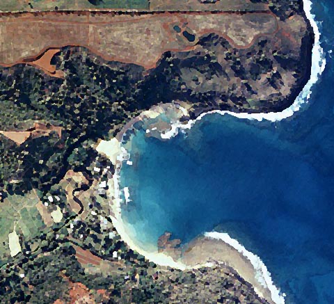
a portion of Moloaa Bay Ranch spreads across the top half of this image

by Juan Wilson on 12 December 2005

There will a regularly scheduled meeting of the Kauai Planning Commission on Tuesday December 13th at at 1:30pm (note this is often an optimistic estimate):

Lihue Civic Center, Moikeha Building
Meeting Room 2A & 2B
4444 Rice Street, Lihue, Kauai, Hawaii

Please attend and let your voice be heard on the issue.

The subject of the meeting will include The Special Management Area Use Permit (SMA) U-2006-2 for Moloaa Bay Ranch LLC (MBR) to allow construction of a perimeter fence, retaining wall (to protect an existing un-permitted reservoir and pump station), the planting of new landscaping with associated irrigation system and grading associated with road reclamation, paving and repair.

I ask the Planning Commission not grant the SMA Permit unless the following items are a condition.

• On more than one occasion spokesmen for the MBR have given the example of "trespassers" picnicking and flying kites on that hillside as the reason why their perimeter security fence is needed. Couldn't the MBR find a greater misuse of the land: like maybe cutting down trees or riding ATV's across the steep hillsides or constructing un-permitted structures? The perimeter fence should not be permitted until the DLNR surveys and determines the path of the public trail defined in the deed to the land. The SMA Permit should accept the historic and archeological review by the county that resulted in a recommendation to place the fence more than 50 feet mauka from the DLNR designated trail.

• The proposed retaining wall is intended to reinforce a reservoir and pump station built precariously on Conservation District land within the Special Management Area without a permit. For the safety of the slope and ocean below this reservoir should be filled and the pump station dismantled rather than reinforced.

• After the un-permitted clear cutting of ironwood trees on the steep slopes above the bay there were mud slides and damage to the ocean reef as a result. Given the history, the landscaping judgment and good intentions of this owner should suspect. The SMA Permit should specify that the National Tropical Botanical Gardens (NTBG) planting plan, that MBR itself commissioned, to replace the current plan.

• Since the mudslide the hillside has had several years of natural recovery, despite the misguided efforts of MBR. If the NTBG plan is followed, there will be no need for the proposed irrigation system or any regrading for landscaping purposes. In addition, any planting program should be required adhere to a phased schedule that is limited to five acre segments. As a result, the NTBG plan will not require heavy equipment to be introduced on the steep slopes.

• There are no roads on the site in the area of the permit. What may have been horse trails and animal paths have been subsequently used by the owner riding ATV's and 4WD vehicles. This does not justifying grading for automobile traffic on paved roads. With the NTBG plan the maintenance requirements of the site would not require paved roads for access by landscaping maintenance equipment.

• The Kauai Planning Department has made a suggestion that the owner be required to submit a Site Master Plan after the MBR gets a permit for any residential development on the site. That Master Plan would be required to provide public access and parking on the north side of Moloaa Stream by way of Moloaa Hui Road. That is a good idea, but the SMA Permit should require that the Site Master Plan be submitted with any request for development. If a permit is granted first, without the Master Plan, the County will have less leverage as events unfold

SUBJECT: MOLOAA BAY RANCH CDUP PERMIT

SOURCE: JUDY DALTON dalton@aloha.net
POSTED: 19 November 2005 - 8:30am HST
Sierra Club submits letter to the Garden Island News

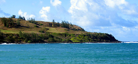
the western shore of Moloaa Bay showing the ranch promontory as it appeared this summer

Attend the November 22nd Planning Commission Public Hearing
Lihue Civic Center, Moikeha Building
Meeting Room 2A & 2B
4444 Rice Street, Lihue, Kauai, Hawaii

Moloaa Bay Ranch Development
by The Kauai Group: Hawaii Chapter Sierra Club on 18 November 2005
Unknown to most hikers and residents, many of Kauai's traditional and customary trails, public easements, beach accesses, and old government roads are in jeopardy.

For decades, the County and State have been reluctant to legally claim these resources, due to budget constraints, and maintenance and liability issues. The consequence is that public right-of-ways are being lost to private entities at an alarming rate.

Community attention needs to focus on requiring state and county officials to collaborate and resolve the operational, legal and jurisdictional issues of all the valuable public trails and access issues we take for granted but have not been properly recorded.

This predicament is causing concern in Moloaa. The historic Moloa`a Trail which traverses between Moloa`a Bay and Larsen's Beach, is known as a segment of the ancient Hawaiian Ala loa, a long-distance trail/footpath. Well documented as a traditional and historic-era access route, the trail goes along the coastal hillside bluffs of Moloa`a Bay Ranch (MBR), to the limu-kohu harvesting areas.

Although MBR recognizes DLNR's authority to establish the trail, as noted in the 1932 deed reservation, it has not been surveyed. In a DLNR Legislative Report, dated November 2000, it states that there have been coordinated efforts between MBR and the State for the establishment of Moloa`a Coastal Trail, however, the survey has never been done. Therefore, MBR's proposal to construct a three rail perimeter fence, alongside the trail is premature.

The 1999 Archeological Assessment prepared for MBR recognizes the significance of this historic trail and the need to preserve it. Along with the Cultural Impact Assessment, dated July 2003 both reports recommend that "no ground disturbing activities such as bulldozing, mechanized vegetation clearing or construction activities occur by the trail".

Looking at photographs of the trail in the Archeological Assessment, it is evident that the trail does not look the same today. Rocks have been moved to facilitate mowing and the former protective layer of ironwood needles is giving way to weeds that hide the footpath. The natural landscape that did not need maintenance, will now require herbicides and pesticides to be used "whenever needed" according to MBR.

When DLNR staff visited the site on November 2000, they reported that 6 to 7 dead ironwood trees exist on the property within the conservation district… We understand that MBR intends, through its agents, to cut down by hand held tools and chainsaws only: 6 to 7 dead ironwood trees…" Two years later, MBR's SMA Permit Application, dated November 2002 states: "The applicant has removed approximately 126 ironwood trees."

For decades, what was once pasture land, now has permits pending for ground clearing, grading, landscaping, irrigation lines, grassing and roadways throughout the steep sloping hillside.

The question to ask is: Why is MBR spending almost $400,000 to alter 45 acres of Special Management Area and Conservation District land? Why will they spend $130,000 on plants and planting, $8,000 on roads, $35,000 on grading? The owners do not plan to live there and their representatives insist there is no master plan for development.

In a letter to the Planning Commission, Senator Hooser cautions that "although the installation of a perimeter fence and new interior roadways may seem unobtrusive, it is most likely that these actions are the precursor for future construction and additional development of the area".

The coastal environment from between Moloaa and Larsen's Beach is recognized in the Kaua`i County General Plan as an "Important Land Form" on the Kawaihau Planning District Heritage Resources Map. Appropriate management of this critical resource is required. It is the intent of Hawaii state law (HRS 205 A-2) to protect and preserve coastal scenic and open space resources; and to not alter the natural landforms and existing public views to and along the shoreline.

To quote Senator Hooser again: "The Moloaa coastline represents an increasingly rare and fragile public asset. It is critical that action be taken now to preserve this valuable asset so that many years from now future generations might also enjoy the experience of walking along a wild ocean bluff."

Residents are encouraged to attend the Planning Commission's public hearing on November 22, 2005. There is clear documentation of MBR's history of non-permitted activities and after-the-fact permits. Further alterations to this pristine coastal environment should be restricted to preserve the natural beauty of this coastline.


see also Island Breath: Sierra Club MBR recommendations

SUBJECT: MOLOAA BAY RANCH CDUP PERMIT

SOURCE: JUAN WILSON juanwilson@mac.com

POSTED: 7 November 2005 - 11:30am HST

Counterpoint to Greg Kingsley TGI "Guest Viewpoint"


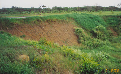
2 July 2002 photo of un-permitted reservoir retaining wall failure on Moloaa Bay Ranch

Moloaa Bay Ranch Timeline
by Malama Molaa 6 November 2006

A Special Management Area Use Permit (SMA(U)-2006-2) is currently being deliberated by the Kauai County Planning Commission.

A “Moloa’a Bay Timeline” documenting years of illegal activity at Moloaa Bay Ranch.

McCloskey and Company project manager Greg Kingsley described a relationship with his boss going back many years. Mr. Kingsley told Planning Commissioners he was a “nanny” for McCloskey’s children. TGI published a “Guest Viewpoint” by Mr. Kingsley October 27, 2005 supporting Tom McCloskey and the Moloaa Bay Ranch (MBR) SMA application.

While Mr. Kingsley’s loyalty to Tom McCloskey is admirable it is a relief that TGI presented his contentions as “viewpoint” and not necessarily as fact:

The issue before the SMA is that mud flowed under MBR’s gate and inundated a residence on Hui Road A. Whether the resident was paid to move is not relevant. The proposed grading plan for the steep SMA slope calls for just one silt fence. See “Timeline” photos (citation 33) showing mud flow breaching MBR’s silt fence and flowing onto Moloa’a Beach. “Timeline” August 2002 and April 2003 photos show the mud flows unabated (citations 30, 32 & 33).

On MBR’s tour October 5, 2005 Planning Commissioners and the public saw that proposed roads are not pre-existing. It is bewildering Mr. Kingsley’s claim “no new roads are being constructed”.

MBR was fined August 1999 for removing trees in the SMA. See the “Timeline” for this DLNR fine (citation 11) and photos showing MBR workers poisoning ironwood resprouts September 1999 (citation 16). Why is Mr. Kingsley claiming “The removal of ironwoods, which necessitated this (SMA) application, happened in 2001.”? Why did MBR’s attorney testify September 30, 2005 before the Planning Commission, that no trees were removed before 2000?

Perhaps it’s to support Mr. Kingsley’s contention that “We have never done and will never do anything to cause mud to flow into Moloa’a Bay.”

“Timeline” 2002 photos shows the SMA hillside gave way (citation 26) and mud flowing from MBR onto Moloaa Beach (citation 30). MBR’s paid consultants suggested during the Sept 30th Commission hearing these flows were caused by ironwoods and did not mention the years of un-permitted and illegal tree cutting, grubbing and, grading.

Mr. Kingsley’s “viewpoint” is “State and Local notification have never been and will never be ignored.” The “Timeline” documents years of unheeded notifications including burning, grubbing. grading and tree cutting.

At this time notifications were being unheeded nearby at Pila’a by Jimmy Pflueger with mud inundating a residence and the reef. MBR manager Jeff Rivera voiced his viewpoint at Malama Moloa’a’s taped meeting July 2001; “ Jimmy Pfleuger is nuts. He got money, he don’t care. He going to pay the fine he figured. So McCloskey, lolo, he listen to him and did the same thing.” (See “Timeline” citation 22)

Mr Kingsley’s “viewpoint” is that access over and along Koolau Japanese Cemetery is “entirely legal”. Kauai Planning Department issued a letter June 2002 showing MBR’s use of this access for this residential CPR has been illegal all along (see “Timeline” vitiation 32).

Mr. Kingsley’s attempts to deny the “deeded public trail ” while acknowledging a “deed reservation for a trail near the high water mark whose location was to have been established by the Commissioners of Public Lands”. This goes along with McCloskey’s bewildering contention that the Commissioners of Public Lands were to locate a private trail with no public access rights (see “Timeline” citation 17).

The CDUA/SMA process must stop the illegal activity:
• Claiming the public trail is private.
• Claiming access through and along Koolau Japanese Cemetery.
• Will Kauai County be liable if the illegally made reservoirs fail?
• Will MBR block access from Hui Road A to the beach?

Malama Moloa’a asks that the SMA hillside not be graded again. That would just destabilizing what nature has healed to date.


www.islandbreath.org

Pau