SUBJECT: MOLOAA BAY RANCH TRAIL
SOURCE: JUAN WILSON juanwilson@mac.com
POSTED: 13 FEBRUARY 2008 - 9:00am HST
Commission tables Moloaa Ranch decision

image above: GoogleEarth view of MBR ranch hilltop. Note deforestation of site and illegal reservoir
as well as route of mudslide if it fails. Previous mudslides on site reached ocean. Click to enlarge.
| by Nathan Eagle on 13 February 2008 in The Garden Island News Representatives from both sides of a North Shore land use debate took turns reacting to the county Planning Commission with dropped jaws, scoffs, hand-waving and head-shaking, yesterday, at the Mo‘ikeha Building. The morning session stretched into the evening as commissioners grappled with how to handle an after-the-fact permit request for Moloa‘a Bay Ranch.After paying $44,000 in fines and publicly apologizing, the landowner wants to keep property improvements that were illegally constructed some six years ago. The violation was to be resolved through an amended special management area use permit for an after-the-fact portion of a pond, pumphouse and rockwall. The commissioners formed a general consensus on what they wanted to do — restore the environmentally sensitive land to its original state — but said they needed extra time to work out the kinks on how to go about it. The decision was tabled until the commission’s next meeting in two weeks. Aside from pulling out the structures, the commissioners got stuck on conditions in the permit that would let Moloa‘a Bay Ranch plant naupaka on the mauka side of a historic coastal trail in order to delineate the path and deter trespassing. The landowner, part-time Kaua‘i resident Tom McCloskey, has scrapped plans to remove ironwood trees, build a perimeter fence and grade portions of the property. “We’re going around in circles,” Moloa‘a Bay Ranch’s attorney, Bill Tam, told the commissioners. The developer initially sought to build a wooden fence along the trail, which skirts the scenic bay, but replaced that plan with hedge planting after the public protested. The commission voted against the naupaka border at one point in the meeting, then reversed its decision. At another point in the session, commissioners said their intention was to have the landowner place signs along the path and then if that fails to keep hikers guided, allow the fence. “Why are we going through this routine?” Tam said. “We have squatters. We have garbage.” Later, the commission went back to the naupaka, approving a condition that requires it to be planted at least 5 to 10 feet mauka of the trail and be maintained at a height of less than 4 feet. But before any planting can occur, the condition requires the landowner to return to the commission and prove there is a need for such a barrier between the private and public property. “It’s ridiculous to spend the time doing it,” Tam said, noting 45 photos that show people trespassing and conducting other illegal activities on Moloa‘a Bay Ranch. “You have to keep the people on the trail. Signage doesn’t work,” county planner Michael Laureta said. Even the approved permits seemed questionable near the close of the discussion on this agenda item. Laureta asked the commission if there was still a need for the permit since all the proposed uses were withdrawn or demanded to be removed. The county in 2001 cited Moloa‘a Bay Ranch in part for not having permits to build a 560,000-gallon agricultural irrigation pond that straddles environmentally sensitive land protected under state law. This “hole in the ground the size of a swimming pool,” Tam said, is significantly safer than required by law. But Commissioner Ted Daligdig said the issue is not whether it meets the county engineer’s approval, “the point is it’s after the fact.” Where the county in the past has forced small landowners to remove unpermitted structures, he said, the Planning Department is now recommending this big developer leave these improvements in place. “This is a huge landowner. They should know better,” said Daligdig, who has served five years on the commission. “We have not kept the same standard with smaller landowners.” Commissioner Sandi Kato-Klutke agreed. “For them to have the audacity to build in an area outside of where they could ... it’s just blatant,” she said. “If it was anybody else,” she added, they would have been severely fined and forced to remove the unpermitted structures. Commission Chair Steve Weinstein said he would not have approved the pond that extends into the special management area. “But just flushing the whole thing down the drain at this point would not solve it,” he said, noting his confidence in compromise. Life-long Moloa‘a residents and environmental group leaders urged the commission to protect the sacred land. After telling a story about growing up walking to work and school along the trail, 75-year-old Loke Perreira said preserving the path is important so the next generation may use it too. She later added that if forced to decide, naupaka would be preferable to a fence and signs. |
SUBJECT: MOLOAA BAY RANCH TRAIL
SOURCE: JUAN WILSON juanwilson@mac.com
POSTED: 13 FEBRUARY 2008 - 9:00am HST
McCloskey continues false trail claims
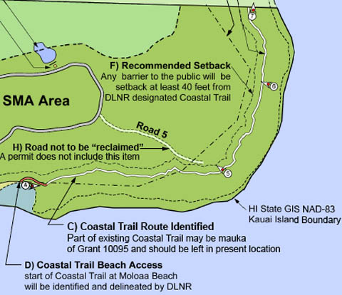
image above: Sierra Club GPS identified coastal trail route (C) mapped in 2006 mauka of MBR route
[Editor's Note: The Sierra Club of Kauai established that the Moloaa Bay Ranch (MBR) claim that the historic Coastal Trail route was at the base of the cliffs along the rocks was not true, and identified where the trail was along the top of the cliffs using a GPS system to follow the worn path. The DLNR should have surveyed the path themselves, but rather than spend the money or energy, let the MBR do the survey. This has resulted in an incorrect alignment of the path favoring MBR properties.] Hikers say historic trail has been moved |
see also:
Island Breath: Moloaa Bay Ranch 3 7/26/06
Island Breath: Moloaa Bay Ranch 2 12/12/05
Island Breath: Moloaa Bay Ranch 1 10/8/05