INDEX - SOVEREIGNTY
www.islandbreath.org ID#0814-28

SUBJECT: HAWAIIAN SOVEREIGNTY

SOURCE: JUAN WILSON juanwilson@mac.com

POSTED: 2 DECEMBER 2008 - 11:00am HST

Moku-Ahupuaa Divisions on Kauai
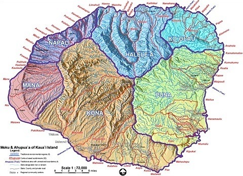
image above: detail of Moku-Ahupuaa map. Click to enlarge. Visi tthe IB FTP Site for PDF latest files (2/28/1011)

by Juan Wilson on 2 December 2008

After the Kauai Mokupuni meeting, on 21 November 2008, I was asked by two representatives of the Aha Kiole Advisory Committee to provide a map of Kauai that would identify its traditional Moku regions and Ahupuaa districts.

This map would be part of a progress report to the Hawaii State legislature as a requirement to be met by the Aha Kiole Adisory Committee. The map would represent a preliminary determination of Hawaiian cultural districts, and provide a basis for determining the divisions of a future Aha Moku Council.

For a few years I and my colleague, Jonathan Jay, have been working on variations of such a map. We have used GIS software (Ggeographic Information Systems) to create the cartography in line with Hawaii State GIS systems.

MOKU REGIONS
We used six rather than the five five mokus identified by the state and commonly used today. The reason was a map we discovered two years ago. Our reference is the 1837 map created by Kalama of the moku for all islands in the Hawaiian system. The source for the map was www.DavidRunmsey.com. See our previous effort here.

from David Rumsey citation:

This is the first separate map of the Hawaiian Islands published in Hawaii. It was engraved and drawn by Kalama, one of the best student engravers at the Lahainaluna Mission School on Maui, who made the larger 1838 Map of the Hawaiian Islands, of which only two copies are known. This 1837 map probably served as a prototype for the 1838 map. It was the most detailed map yet published, showing many place names on the islands unfamiliar to Cook and Vancouver and not appearing on their maps, exceeded in detail only by the enlarged 1838 edition which added more place names.

We mapped the Kalama moku to the watershed boundaries provided by the state database.

AHUPUAA DISTRICTS
Through the Aha Moku meetings, over the last year we learned that ahupuaa did not just follow watershed lines, but also were occasionally along stream beds.

When we tried to use the state ahupuaa boundaries on our map we found bizarre geometries that followed no physical features of the island.

• We found boundaries following a stream and then jumping in a straight to a mountaintop.

• We found ahupuaa crossing watershed ridge lines.

• We found boundaries with no reference to physical features of the island.

We have used a combination of Hawaii State data and Kauai Historical Society records to produce the ahupuaa boundaries.

We then tried to map the ahupuaa names to the states watershed maps. When mapped to watershed boundaries many ahupuaa made more sense. Some ahupuaa were made up of several small watersheds. However, some ahupuaa seemed to split a watershed. After considering the state contour data it seemed some ahupuaa could be split by streambeds.

After re-mapping the boundaries we feel we had a fairly good view of ahupuaa boundaries with only a few exceptions. One ahupuaa that was lost was Olehena. We now believe this is due to errors in the state watershed map that incorporates man made canals, used for sugarcane production, in the determination of natural watersheds. A deeper analysis of contours may resolve the few traditional ahupuaa we have failed to delineate.

We are seeking reactions to this map that will improve and refine it as a useful tool to the Hawaiian community and ultimately to our own. We recognize that within the Hawaiian cultural record are the seeds we need to plant to live on these islands sustainably.


SUBJECT: HAWAIIAN SOVEREIGNTY

SOURCE: LEIMANA DAMATE leimana@fastnethi.com

POSTED: 21 NOVEMBER 2008 - 2:30pm HST

Aha Moku Systems - Mokupuni Meeting

image above: Aha Kiole Advisory Council graphic

by Leimana DaMate on 18 November 2008

WHAT:
Aha Moku Systems Meeting

WHEN:
Friday, 21 November, 2008, 5:00pm-8:00pm

WHERE:
Kauai Community College

CONTACT:
Leimana DaMate, Community Coordinator
Aha Kiole Advisory Committee
Phone: 808-497-0800
Email: leimana@fastnethi.com


On behalf of the Aha Kiole Advisory Committee, Kauai Kiole Sharon Pomroy, Niihau Kiole Ilei Beniamina, and Kona Hema Moku Representative Billy Kaohelaulii, we invite you to attend a public community Aha Moku Systems meeting on Friday, November 21, 2008 at the Campus Center, Kauai Community College. The meeting will be from 5:00 p.m. to 8:00 p.m.

The purpose of the meeting is to give the people of Kauai and Niihau, the Hawaiian organizations and the general public a status report on the Aha Moku system for Kauai and Niihau; to get acceptance for this grassroots community consultation process; to identify moku issues and concerns; and to finalize the process on the moku structure. The results of this meeting will be part of the Final Legislative Report on the Aha Moku Systems that will be submitted to the Hawaii State Legislature in December 2008.

Please let as many people as possible know about this meeting. All of Kauai’s legislators, County Council, Planning Depts., and Hawaiian organizations have received notices of this meeting so we have to have our Hawaiians and locals there too.

Act 212 – the Aha Moku System

"The purpose of this Act is to initiate the process to create a system of best practices that is based upon the indigenous resource management practices of moku (regional) boundaries, which acknowledges that natural contours of land, the specific resources located within those areas, and the methodology necessary to sustain resources and the community.

The 'Aha Moku System will foster understanding and practical uses of knowledge, including native Hawaiian methodology and expertise, to assure responsible stewardship and awareness of the interconnectedness of the clouds, forest, valleys, land, streams, fishponds and seas.

The System will include the use of community expertise and establish programs and projects to improve communication, education, provide training on stewardship issues through out the region (moku), and increase education."

Please feel free to contact Kauai Kiole, Sharon Pomroy at 808-346-6725, email: pomroys001@hawaii.rr.com; or Niihau Kiole, Ilei Beniamina at 808-639-0437, email: jeanilei@yahoo.com; Billy Kaohelaulii, Kona Akau Moku Representative, at 742-9575, email: terrihayes@gmail.com; or myself, Leimana DaMate at leimana@fastnethi.com, the Aha Kiole Community Coordinator should you have any questions or visit our website, www.ahakiole.org

We truly hope you can join us.

see also:
Island Breath: Eastside Aku Kiole Meeting
5/30/08
Island Breath: Aku Moku Meeting
3/11/08
Island Breath: Kona Central Meeting
2/13/08
Island Breath: Kauai District Meetings
1/12/1/07
Island Brath: 4th Eco Roundtable
11/9/07
Island Breath: TGI #16 Kauai Land Use
11/1/07
Island Breath: Kahoolawe case closeing
5/28/08
TGI #29: Hawaiian Nation History - Part Two
5/4/08
TGI #28: Hawaiian Nation History - Part One
4/25/08
Island Breath: State loses in "Ceded" land case
3/1/08


Pau
www.islandbreath.org